
City View topographic map
Click on the map to display elevation.
About this map
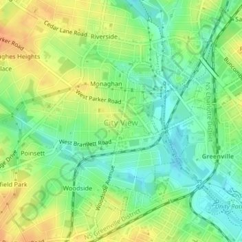
Name: City View topographic map, elevation, terrain.
Location: City View, Greenville County, South Carolina, United States (34.85686 -82.43669 34.86612 -82.41328)
Average elevation: 974 ft
Minimum elevation: 919 ft
Maximum elevation: 1,037 ft
Greenville County trails, hiking, mountain biking, running and outdoor activities
Other topographic maps
Click on a map to view its topography, its elevation and its terrain.
Marietta
United States > South Carolina > Greenville County > Slater-Marietta
Average elevation: 1,040 ft
Homestead Acres
United States > South Carolina > Greenville County > Taylors
Average elevation: 945 ft
Kendall Green
United States > South Carolina > Greenville County > Greenville
Average elevation: 978 ft
Isaqueena Park
United States > South Carolina > Greenville County > Greenville
Average elevation: 974 ft
Cleveland Forest
United States > South Carolina > Greenville County > Greenville
Average elevation: 942 ft
Sherwood Forest
United States > South Carolina > Greenville County > Greenville
Average elevation: 961 ft
Sunny Acres
United States > South Carolina > Greenville County > Travelers Rest
Average elevation: 1,070 ft
Slater
United States > South Carolina > Greenville County > Slater-Marietta
Average elevation: 1,063 ft
Mount Vernon Estates
United States > South Carolina > Greenville County > Greer
Average elevation: 991 ft
Little Table Rock Mountain
United States > South Carolina > Greenville County
Average elevation: 2,927 ft
Morningside
United States > South Carolina > Greenville County > Wade Hampton
Average elevation: 984 ft
Orchard Acres
United States > South Carolina > Greenville County > Wade Hampton
Average elevation: 958 ft
Piney Ridge
United States > South Carolina > Greenville County > Wade Hampton
Average elevation: 997 ft
Glenwood Acres
United States > South Carolina > Greenville County > Greenville
Average elevation: 1,001 ft
Crescentwood Village
United States > South Carolina > Greenville County > Mauldin
Average elevation: 906 ft
Evergreen Place
United States > South Carolina > Greenville County > Greenville
Average elevation: 945 ft
Stone Lake
United States > South Carolina > Greenville County > Greenville
Average elevation: 1,001 ft