
Make a donation
Gear up for your next adventure:
As an Amazon Associate, this site earns from qualifying purchases at no extra cost to you.
Fischenthal topographic map
Click on the map to display elevation.
Make a donation
Gear up for your next adventure:
As an Amazon Associate, this site earns from qualifying purchases at no extra cost to you.
Fischenthal
Hauptachse ist die Tösstalstrasse Winterthur–Turbenthal–Bauma–Wald–Rüti–Rapperswil durch Fischenthal, als kürzeste Verbindung von Winterthur in den St. Galler Seebezirk. Von diesem Hauptstrang zweigen im Fischenthal auch Querverbindungen ab. In Steg im Tösstal nach Osten die Hulfteggstrasse (Passhöhe 953 m) ins Toggenburg und den Hinterthurgau. In Gibswil nach Nordwesten die Abzweigung nach Kleinbäretswil–Ghöch (Passhöhe 961 m)-Bäretswil, ebenda nach Westen über die Schufelberger Egg (Passhöhe 990 m) und zugleich höchstgelegener öffentlich befahrbarer Übergang im Kanton Zürich, nach Girenbad (Hinwil) und von Gibswil nach Südwesten über Hueb-Orn nach Wernetshausen (Hinwil). Die drei Verzweiger ab Gibswil führen auf die befahrbare Höhen-Längsachse auf der Almenkette: Bachtel–Bäretswil–Hittnau–Russikon–Weisslingen–Kyburg.
Make a donation
Gear up for your next adventure:
As an Amazon Associate, this site earns from qualifying purchases at no extra cost to you.
About this map
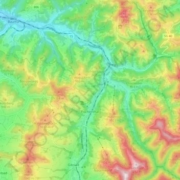
Name: Fischenthal topographic map, elevation, terrain.
Location: Fischenthal, Bezirk Hinwil, Zürich, Schweiz (47.30712 8.88834 47.37592 8.98494)
Average elevation: 2,831 ft
Minimum elevation: 2,083 ft
Maximum elevation: 4,035 ft
Make a donation
Gear up for your next adventure:
As an Amazon Associate, this site earns from qualifying purchases at no extra cost to you.
Other topographic maps
Click on a map to view its topography, its elevation and its terrain.
Make a donation
Gear up for your next adventure:
As an Amazon Associate, this site earns from qualifying purchases at no extra cost to you.
Bachtel
Schweiz > Zürich > Bezirk Hinwil > Hinwil
Südöstlich, unterhalb des Gipfels, liegt auf ca. 955 Meter Höhe der Bachtelspalt. Es handelt sich um eine Spalte, die 1939 beim Abrutschen eines NagelfluhKopfes entstand. Sie ist begehbar, aber sehr eng.
Average elevation: 2,848 ft
Make a donation
Gear up for your next adventure:
As an Amazon Associate, this site earns from qualifying purchases at no extra cost to you.