Geolocate

Emmet topographic map

Click on the map to display elevation.

About this map

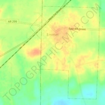
Name: Emmet topographic map, elevation, terrain.

Location: Emmet, Nevada County, Arkansas, 71835, United States (33.70906 -93.47853 33.73297 -93.45702)

Average elevation: 292 ft

Minimum elevation: 223 ft

Maximum elevation: 338 ft

Nevada County trails, hiking, mountain biking, running and outdoor activities

Other topographic maps

Click on a map to view its topography, its elevation and its terrain.

Delta

United States > Arkansas > Nevada County

Average elevation: 348 ft

Gear up for your next adventure:

🥾Men's Hiking Boots - Durable, waterproof footwear for rugged terrain and steep inclines
🔭Compact Binoculars - HD vision for scouting terrain and identifying distant landmarks
🌧️Backpack Rain Cover - Keep gear dry in wet weather
🏔️Mountain Trail Maps - High‑detail maps for popular peaks
🧷Carabiner Set - Durable clips for gear attachment

As an Amazon Associate, this site earns from qualifying purchases at no extra cost to you.