
Make a donation
Gear up for your next adventure:
As an Amazon Associate, this site earns from qualifying purchases at no extra cost to you.
Greenland topographic map
Click on the map to display elevation.
Make a donation
Gear up for your next adventure:
As an Amazon Associate, this site earns from qualifying purchases at no extra cost to you.
Greenland
The climate in this area is characterized by hot, extremely humid summers and generally cool to very cold winters depending on elevation. According to the Köppen Climate Classification system, Greenland has a humid subtropical climate, abbreviated "Cfa" on climate maps.
Make a donation
Gear up for your next adventure:
As an Amazon Associate, this site earns from qualifying purchases at no extra cost to you.
About this map
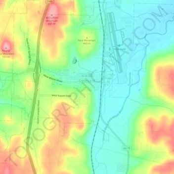
Name: Greenland topographic map, elevation, terrain.
Location: Greenland, Washington County, Arkansas, 72737, United States (35.96970 -94.21533 36.01651 -94.17003)
Average elevation: 1,375 ft
Minimum elevation: 1,207 ft
Maximum elevation: 1,631 ft
Washington County trails, hiking, mountain biking, running and outdoor activities
Make a donation
Gear up for your next adventure:
As an Amazon Associate, this site earns from qualifying purchases at no extra cost to you.
Other topographic maps
Click on a map to view its topography, its elevation and its terrain.
Make a donation
Gear up for your next adventure:
As an Amazon Associate, this site earns from qualifying purchases at no extra cost to you.
Make a donation
Gear up for your next adventure:
As an Amazon Associate, this site earns from qualifying purchases at no extra cost to you.
Make a donation
Gear up for your next adventure:
As an Amazon Associate, this site earns from qualifying purchases at no extra cost to you.