Geolocate

Capdepera topographic map

Click on the map to display elevation.

About this map

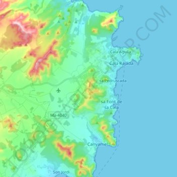
Name: Capdepera topographic map, elevation, terrain.

Location: Capdepera, Llevant, Balearic Islands, Spain (39.63497 3.38110 39.75183 3.47875)

Average elevation: 210 ft

Minimum elevation: -3 ft

Maximum elevation: 1,273 ft

Other topographic maps

Click on a map to view its topography, its elevation and its terrain.

Portocristo

Spain > Balearic Islands > Llevant

Average elevation: 82 ft

Manacor

Spain > Balearic Islands > Llevant

Average elevation: 328 ft

Cales de Mallorca

Spain > Balearic Islands > Llevant

Average elevation: 82 ft

S'Illot

Spain > Balearic Islands > Llevant

Average elevation: 13 ft

Gear up for your next adventure:

🧭Map Reading Tools - Tools and kits for map navigation
🪑Portable Camp Table - Compact table for campsite meals
Camping Coffee Makers - Enjoy premium coffee at the summit or campsite
🗺️Topographic Maps - Detailed topo maps for hiking, exploring and outdoor navigation
🕶️Glacier Sunglasses - Side shields to protect eyes from high-altitude snow glare

As an Amazon Associate, this site earns from qualifying purchases at no extra cost to you.