Geolocate

Wickliffe topographic map

Click on the map to display elevation.

About this map

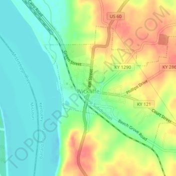
Name: Wickliffe topographic map, elevation, terrain.

Location: Wickliffe, Ballard County, Kentucky, United States (36.95573 -89.09780 36.97474 -89.06950)

Average elevation: 361 ft

Minimum elevation: 279 ft

Maximum elevation: 469 ft

Ballard County trails, hiking, mountain biking, running and outdoor activities

Other topographic maps

Click on a map to view its topography, its elevation and its terrain.

Slater

United States > Kentucky > Ballard County

Average elevation: 443 ft

Gear up for your next adventure:

🚪Portable Camp Chair - Foldable chair for comfort at camp
🔦Compact Flashlight - Reliable flashlight for emergencies
🔭Stargazing Telescopes - Perfect for camping in low-light pollution areas shown on maps
🔥Plasma Lighters - Windproof lighters that work in any weather condition
🥇GPS Hiking Watch - Multi‑sport GPS watch with navigation and trail tracking

As an Amazon Associate, this site earns from qualifying purchases at no extra cost to you.