Geolocate

Footville topographic map

Click on the map to display elevation.

About this map

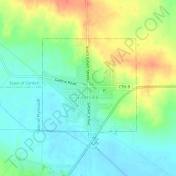
Name: Footville topographic map, elevation, terrain.

Location: Footville, Rock County, Wisconsin, 53537, United States (42.66421 -89.21938 42.67940 -89.19942)

Average elevation: 856 ft

Minimum elevation: 794 ft

Maximum elevation: 958 ft

Rock County trails, hiking, mountain biking, running and outdoor activities

Other topographic maps

Click on a map to view its topography, its elevation and its terrain.

Lima Center

United States > Wisconsin > Rock County

Average elevation: 899 ft

Foxhollow

United States > Wisconsin > Rock County > Town of Turtle

Average elevation: 912 ft

Avalon

United States > Wisconsin > Rock County

Average elevation: 948 ft

Tiffany

United States > Wisconsin > Rock County > Town of Turtle

Average elevation: 860 ft

Cainville

United States > Wisconsin > Rock County

Average elevation: 932 ft

Mount Zion

United States > Wisconsin > Rock County

Average elevation: 938 ft

Gear up for your next adventure:

🎒Hydration Pack - Hands‑free water reservoir for long hikes
🕶️GPS Smartphone Mount - Secure mount for phone navigation
🥩Freeze-Dried Meals - Nutritious and lightweight food for remote expeditions
📱Heavy-Duty Phone Cases - Drop-proof and waterproof protection for outdoor navigation
🪑Portable Camp Table - Compact table for campsite meals

As an Amazon Associate, this site earns from qualifying purchases at no extra cost to you.