Geolocate

Auburn topographic map

Click on the map to display elevation.

About this map

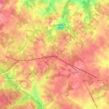
Name: Auburn topographic map, elevation, terrain.

Location: Auburn, Barrow County, Georgia, 30011, United States (33.98021 -83.86523 34.04937 -83.79528)

Average elevation: 984 ft

Minimum elevation: 725 ft

Maximum elevation: 1,112 ft

Barrow County trails, hiking, mountain biking, running and outdoor activities

Other topographic maps

Click on a map to view its topography, its elevation and its terrain.

Russell

United States > Georgia > Barrow County

Average elevation: 915 ft

Gear up for your next adventure:

🎁Geography Themed Gifts - Unique gift ideas for map lovers and geography enthusiasts
🛰️Satellite Messengers - Emergency SOS and two-way messaging for off-grid adventures
🧺Microfiber Travel Towels - Compact and fast-drying towels for trail use
👖Convertible Hiking Pants - Versatile zip-off pants for changing altitudes and temperatures
🥾Men's Hiking Boots - Durable, waterproof footwear for rugged terrain and steep inclines

As an Amazon Associate, this site earns from qualifying purchases at no extra cost to you.