
Make a donation
Gear up for your next adventure:
As an Amazon Associate, this site earns from qualifying purchases at no extra cost to you.
Souss-Massa topographic map
Click on the map to display elevation.
Make a donation
Gear up for your next adventure:
As an Amazon Associate, this site earns from qualifying purchases at no extra cost to you.
Souss-Massa
Three factors influence the semi-arid Mediterranean climate of the region: the topography, the oceanic coastline, and the Sahara Desert. In the northern part, dominated by the Atlas Mountains, the climate shifts from humid to semi-arid as one moves towards the plain. This plain, which stretches from the base of the Atlas and includes the basins of the Souss and Massa rivers, experiences an arid climate despite its broad exposure to the Atlantic Ocean. Meanwhile, the southern and southeastern sections of the region, which lie on the northern edge of the Sahara, have a desert climate.
Make a donation
Gear up for your next adventure:
As an Amazon Associate, this site earns from qualifying purchases at no extra cost to you.
About this map
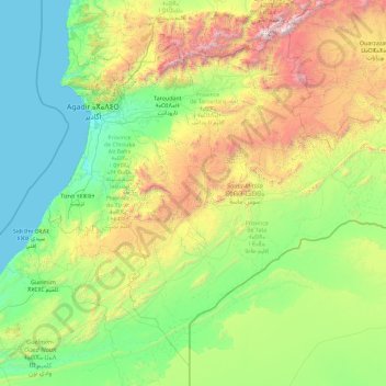
Name: Souss-Massa topographic map, elevation, terrain.
Location: Souss-Massa, Morocco (28.31106 -10.01009 31.16659 -6.35365)
Average elevation: 2,431 ft
Minimum elevation: 0 ft
Maximum elevation: 13,199 ft
Make a donation
Gear up for your next adventure:
As an Amazon Associate, this site earns from qualifying purchases at no extra cost to you.
Other topographic maps
Click on a map to view its topography, its elevation and its terrain.
Atlas Mountains
Morocco > cercle de Taliouine > Toubkal ⵜⵓⴱⵇⴰⵍ توبقال
The Atlas Mountains are a mountain range in the Maghreb in North Africa. It separates the Sahara Desert from the Mediterranean Sea and the Atlantic Ocean; the name "Atlantic" is derived from the mountain range, which stretches around 2,500 km (1,600 mi) through Morocco, Algeria and Tunisia. The range's highest…
Average elevation: 11,161 ft
Marrakesh
Morocco > Pachalik de Marrakech > Marrakesh
By road, Marrakesh is located 580 kilometres (360 mi) southwest of Tangier, 327 kilometres (203 mi) southwest of the Moroccan capital of Rabat, 239 kilometres (149 mi) southwest of Casablanca, 196 kilometres (122 mi) southwest of Beni Mellal, 177 kilometres (110 mi) east of Essaouira, and 246 kilometres (153…
Average elevation: 1,591 ft
Carrière Ben Abid
Morocco > Casablanca-Settat > Cercle de Sahel Trifiya دائرة الساحل-الطريفية > Soualem Trifiya > Douar Carrière Benabid
Average elevation: 85 ft
Make a donation
Gear up for your next adventure:
As an Amazon Associate, this site earns from qualifying purchases at no extra cost to you.
Oulad M'Rabet
Morocco > Marrakech-Safi > Cercle d'Essaouira دائرة الصويرة > Oulad M'Rabet أولاد امرابط
Average elevation: 1,283 ft
Tighza
Morocco > Béni Mellal-Khénifra > Cercle d'Aguelmous دائرة أكلموس > El Hammam
Average elevation: 3,766 ft
Tadmante ⵜⴰⴹⵎⴰⵏⵜ تدممت
Morocco > Tangier-Tetouan-Al Hoceima > Cercle de tétouan دائرة تطوان > Bni Said بني سعيد
Average elevation: 1,663 ft
Make a donation
Gear up for your next adventure:
As an Amazon Associate, this site earns from qualifying purchases at no extra cost to you.
Oued El Kanar
Morocco > Tangier-Tetouan-Al Hoceima > Cercle de Bou Ahmed دائرة بو أحمد > Stehat اسطيحة
Average elevation: 1,519 ft
Toubkal
Morocco > Marrakech-Safi > Cercle d'Asni > Asni
Toubkal, also Jbel Toubkal or Jebel Toubkal, is a mountain in southwestern Morocco, located in the Toubkal National Park. At 4,167 m (13,671 ft), it is the highest peak in Morocco, the Atlas Mountains, North Africa and the Arab world. Located 63 km (39 mi) south of the city of Marrakesh, and visible from it,…
Average elevation: 11,864 ft
Fifird
Morocco > Souss-Massa > cercle de Foum Zguid دائرة فم زكيد > Aguinane ⴰⴳⵉⵍⴰⵍ اكينان > Fighile
Average elevation: 5,095 ft
Make a donation
Gear up for your next adventure:
As an Amazon Associate, this site earns from qualifying purchases at no extra cost to you.
Meski
Morocco > Drâa-Tafilalet > Cercle d'Errachidia دائرة الرشيدية > Chorfa M'Daghra
Average elevation: 3,261 ft
Ouslaf
Morocco > Tangier-Tetouan-Al Hoceima > Cercle de Bou Ahmed دائرة بو أحمد > Akchour أقشور
Average elevation: 2,175 ft
Make a donation
Gear up for your next adventure:
As an Amazon Associate, this site earns from qualifying purchases at no extra cost to you.
plage rose marie
Morocco > Rabat-Salé-Kénitra > Pachalik de Skhirat > Skhirat
Average elevation: 30 ft
Aït Benhaddou
Morocco > Drâa-Tafilalet > Cercle d'Amerzgane دائرة أمرزكان > Ait Zineb
Average elevation: 4,324 ft
Make a donation
Gear up for your next adventure:
As an Amazon Associate, this site earns from qualifying purchases at no extra cost to you.
Toubkal
Morocco > cercle d'Asni > Asni
Toubkal (Arabic: توبقال, romanized: tūbqāl, pronounced [tuːbqaːl]), also Jbel Toubkal or Jebel Toubkal, is a mountain in southwestern Morocco, located in the Toubkal National Park. At 4,167 m (13,671 ft), it is the highest peak in Morocco, the Atlas Mountains, North Africa and the Arab world. Located…
Average elevation: 11,864 ft
Douar Jadid F.B.S
Morocco > Béni Mellal-Khénifra > cercle de Fquih Ben Salah دائرة الفقيه بن صالح
Average elevation: 1,394 ft
Ifni Lake
Morocco > Souss-Massa > Cercle de Taliouine > Toubkal ⵜⵓⴱⵇⴰⵍ توبقال
Average elevation: 8,507 ft
Parc Écologique d'Oujda
Morocco > Oriental > Pachalik d'Oujda باشوية وجدة > Oujda
Average elevation: 1,677 ft
Make a donation
Gear up for your next adventure:
As an Amazon Associate, this site earns from qualifying purchases at no extra cost to you.
Atlas Mountains
Morocco > cercle de Taliouine > Toubkal ⵜⵓⴱⵇⴰⵍ توبقال
The Atlas Mountains are a mountain range in the Maghreb in North Africa. It separates the Sahara Desert from the Mediterranean Sea and the Atlantic Ocean; the name "Atlantic" is derived from the mountain range, which stretches around 2,500 km (1,600 mi) through Morocco, Algeria and Tunisia. The range's highest…
Average elevation: 11,161 ft
Make a donation
Gear up for your next adventure:
As an Amazon Associate, this site earns from qualifying purchases at no extra cost to you.
Jebel Musa
Morocco > Tangier-Tetouan-Al Hoceima > Cercle de tétouan دائرة تطوان > Belyounech
Average elevation: 1,158 ft
Atlas Mountains
Morocco > cercle de Taliouine > Toubkal ⵜⵓⴱⵇⴰⵍ توبقال
The Atlas Mountains are a mountain range in the Maghreb in North Africa. They separate the Sahara Desert from the Mediterranean Sea and the Atlantic Ocean; the name "Atlantic" is derived from the mountain range, which stretches around 2,500 km (1,600 mi) through Morocco, Algeria and Tunisia. The mountains are…
Average elevation: 11,161 ft
Make a donation
Gear up for your next adventure:
As an Amazon Associate, this site earns from qualifying purchases at no extra cost to you.
Ifegh
Morocco > Drâa-Tafilalet > Cercle de Goulmima دائرة كلميمة > Aghbalou N'Kerdous اغبالو انكردوس
Average elevation: 4,334 ft
Make a donation
Gear up for your next adventure:
As an Amazon Associate, this site earns from qualifying purchases at no extra cost to you.
Ouzina
Morocco > Drâa-Tafilalet > Cercle d'Er-Rissani > Et-taous ⵟⴰⵡⵙ الطاوس
Average elevation: 2,182 ft
Make a donation
Gear up for your next adventure:
As an Amazon Associate, this site earns from qualifying purchases at no extra cost to you.
Dar Barroud
Morocco > Tangier-Tetouan-Al Hoceima > Pachalik de Tanger باشوية طنجة > Tangier
Average elevation: 66 ft
Sidi Addi
Morocco > Fez-Meknes > Cercle d'Azrou دائرة أزرو > Sidi El Makhfi سيدي المخفي
Average elevation: 3,661 ft
Make a donation
Gear up for your next adventure:
As an Amazon Associate, this site earns from qualifying purchases at no extra cost to you.
RP2030
Morocco > Cercle de Tahannaout دائرة تحناوت > Oukaimeden > Ait el Qaq
Average elevation: 8,209 ft
Make a donation
Gear up for your next adventure:
As an Amazon Associate, this site earns from qualifying purchases at no extra cost to you.
Azrou أزرو
Morocco > Oriental > Cercle du Rif Nord دائرة الريف الشمالية > Trougout تروكوت
Average elevation: 778 ft
Make a donation
Gear up for your next adventure:
As an Amazon Associate, this site earns from qualifying purchases at no extra cost to you.
Ksar Taguersift
Morocco > Drâa-Tafilalet > Cercle d'Agdz > Tamezmoute تامزموت
Average elevation: 2,966 ft
Make a donation
Gear up for your next adventure:
As an Amazon Associate, this site earns from qualifying purchases at no extra cost to you.
Plage Blanche ⴰⴼⵜⴰⵙ ⴰⵎⵍⵍⴰⵍ الشاطئ الأبيض
Morocco > Cercle de Laqsabi دائرة القصابي > Echatea El Abied الشاطئ الأبيض > Echatea El Abied
Average elevation: 118 ft
Make a donation
Gear up for your next adventure:
As an Amazon Associate, this site earns from qualifying purchases at no extra cost to you.
Rmilet
Morocco > Tangier-Tetouan-Al Hoceima > Pachalik de Tanger باشوية طنجة > Tanger طنجة
Average elevation: 367 ft
Make a donation
Gear up for your next adventure:
As an Amazon Associate, this site earns from qualifying purchases at no extra cost to you.
Dchar Ouattah مدشر وطاح
Morocco > Tangier-Tetouan-Al Hoceima > Cercle de Loukous > Tatoft
Average elevation: 453 ft
Quaà Asserasse قـاع أسـراس
Morocco > Tangier-Tetouan-Al Hoceima > Cercle de Bou Ahmed دائرة بو أحمد > Tizgane تزكان
Average elevation: 243 ft
Make a donation
Gear up for your next adventure:
As an Amazon Associate, this site earns from qualifying purchases at no extra cost to you.
Souani
Morocco > Cercle de Bni Ouriaghel Acharkia دائرة بني ورياغل > Ait Youssef Ou Ali
Average elevation: 30 ft
Make a donation
Gear up for your next adventure:
As an Amazon Associate, this site earns from qualifying purchases at no extra cost to you.
Make a donation
Gear up for your next adventure:
As an Amazon Associate, this site earns from qualifying purchases at no extra cost to you.
Oued El Ogla
Morocco > Casablanca-Settat > Pachalik de El Mansouria > El Mansouria
Average elevation: 49 ft
Baie de Nekkour
Morocco > Tangier-Tetouan-Al Hoceima > Ajdir أجدير > Sidi Mohamedi
Average elevation: 69 ft
Tizert
Morocco > Marrakech-Safi > Cercle de Tahannaout دائرة تحناوت > Sti Fadma
Average elevation: 4,770 ft
Make a donation
Gear up for your next adventure:
As an Amazon Associate, this site earns from qualifying purchases at no extra cost to you.
Setti Fatma
Morocco > Cercle de Tahannaout دائرة تحناوت > Sti Fadma > Sti Fadma
Average elevation: 6,148 ft
Make a donation
Gear up for your next adventure:
As an Amazon Associate, this site earns from qualifying purchases at no extra cost to you.
Aït Benhaddou
Morocco > Drâa-Tafilalet > Cercle d'Amerzgane دائرة أمرزكان > Ait Zineb
Average elevation: 4,324 ft
Meknes
Morocco > Pachalik de Meknes > Meknes
Each year Meknes holds the International Agriculture Show in Morocco(French: Salon International de l'Agriculture au Maroc) since April 2006. This agriculture show has an area of more than 250000 square meters, with more than 60 countries participating, and more than 1200 exhibitors. The lands around Meknes…
Average elevation: 1,824 ft
Make a donation
Gear up for your next adventure:
As an Amazon Associate, this site earns from qualifying purchases at no extra cost to you.
Make a donation
Gear up for your next adventure:
As an Amazon Associate, this site earns from qualifying purchases at no extra cost to you.
Talat Marghene
Morocco > Cercle de Tahannaout دائرة تحناوت > Aghouatim اغواطيم
Average elevation: 3,294 ft
Make a donation
Gear up for your next adventure:
As an Amazon Associate, this site earns from qualifying purchases at no extra cost to you.
Fontaine de Morroco Mall
Morocco > Pachalik de Casablanca باشوية الدار البيضاء > Casablanca
Average elevation: 39 ft
Parque del Marxán
Morocco > Tangier-Tetouan-Al Hoceima > Pachalik de Tanger باشوية طنجة > Tangier
Average elevation: 95 ft
Make a donation
Gear up for your next adventure:
As an Amazon Associate, this site earns from qualifying purchases at no extra cost to you.