Geolocate

Paxton topographic map

Click on the map to display elevation.

About this map

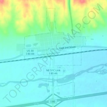
Name: Paxton topographic map, elevation, terrain.

Location: Paxton, Keith County, Nebraska, United States (41.11158 -101.36602 41.13443 -101.34534)

Average elevation: 3,097 ft

Minimum elevation: 3,045 ft

Maximum elevation: 3,271 ft

Other topographic maps

Click on a map to view its topography, its elevation and its terrain.

Belmar

United States > Nebraska > Keith County

Average elevation: 3,333 ft

Lemoyne

United States > Nebraska > Keith County

Average elevation: 3,337 ft

Gear up for your next adventure:

📶Satellite Messenger - Communication device off‑grid
🌄Hiking Binoculars - Compact binoculars for scenic views and trail spotting
🧼Biodegradable Camping Soap - Eco‑friendly soap for outdoor hygiene
Solar GPS Watches - Advanced multisport watches with built-in topographic maps
🔦Powerful Headlamps - Ultra-bright hands-free lighting for night navigation

As an Amazon Associate, this site earns from qualifying purchases at no extra cost to you.