Geolocate

Flynn topographic map

Click on the map to display elevation.

About this map

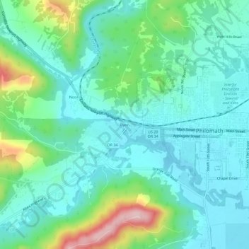
Name: Flynn topographic map, elevation, terrain.

Location: Flynn, Benton County, Oregon, 97370, United States (44.52095 -123.40677 44.56095 -123.36677)

Average elevation: 407 ft

Minimum elevation: 236 ft

Maximum elevation: 958 ft

Benton County trails, hiking, mountain biking, running and outdoor activities

Other topographic maps

Click on a map to view its topography, its elevation and its terrain.

Monroe

United States > Oregon > Benton County

Average elevation: 325 ft

Gear up for your next adventure:

GPS Sports Watch - GPS watch for running, hiking and training
🗺️NatGeo Topo Maps - High-quality waterproof printed topographic maps of US Parks
🥾Hiking Shoes - Durable and comfortable shoes for trail hiking
🍳Camping Cook Set - Complete cookware for outdoor meals
🧭GPS Watch Accessories - Bands and chargers for GPS watches

As an Amazon Associate, this site earns from qualifying purchases at no extra cost to you.