
Make a donation
Gear up for your next adventure:
As an Amazon Associate, this site earns from qualifying purchases at no extra cost to you.
Karns topographic map
Click on the map to display elevation.
Make a donation
Gear up for your next adventure:
As an Amazon Associate, this site earns from qualifying purchases at no extra cost to you.
Karns
Karns is located in the Beaver Creek Valley between Beaver Ridge and Copper Ridge, both of which are elongate ridges typical of the Ridge-and-Valley Appalachians. The center of the community is located at 35°58′55″N 84°06′50″W / 35.98194°N 84.11389°W / 35.98194; -84.11389 (35.982, -84.114). Elevation ranges from about 960 to 1,000 feet (300 m) above sea level. Beaver Creek, a tributary of the Clinch River, flows through the community.
Make a donation
Gear up for your next adventure:
As an Amazon Associate, this site earns from qualifying purchases at no extra cost to you.
About this map
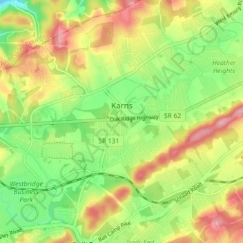
Name: Karns topographic map, elevation, terrain.
Average elevation: 1,030 ft
Minimum elevation: 807 ft
Maximum elevation: 1,293 ft
Knox County trails, hiking, mountain biking, running and outdoor activities
Make a donation
Gear up for your next adventure:
As an Amazon Associate, this site earns from qualifying purchases at no extra cost to you.
Other topographic maps
Click on a map to view its topography, its elevation and its terrain.
Make a donation
Gear up for your next adventure:
As an Amazon Associate, this site earns from qualifying purchases at no extra cost to you.
Make a donation
Gear up for your next adventure:
As an Amazon Associate, this site earns from qualifying purchases at no extra cost to you.
Make a donation
Gear up for your next adventure:
As an Amazon Associate, this site earns from qualifying purchases at no extra cost to you.
Island Home
United States > Tennessee > Knox County > Knoxville > Island Home
Average elevation: 906 ft
Audubon Hills
United States > Tennessee > Knox County > Farragut > Audubon Hills
Average elevation: 886 ft
Highland Park
United States > Tennessee > Knox County > Knoxville > Highland Park
Average elevation: 1,119 ft
Make a donation
Gear up for your next adventure:
As an Amazon Associate, this site earns from qualifying purchases at no extra cost to you.