
Make a donation
Gear up for your next adventure:
As an Amazon Associate, this site earns from qualifying purchases at no extra cost to you.
Heather Heights topographic map
Click on the map to display elevation.
Make a donation
Gear up for your next adventure:
As an Amazon Associate, this site earns from qualifying purchases at no extra cost to you.
About this map
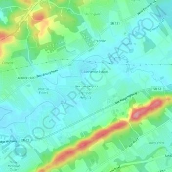
Name: Heather Heights topographic map, elevation, terrain.
Average elevation: 1,043 ft
Minimum elevation: 948 ft
Maximum elevation: 1,325 ft
Knox County trails, hiking, mountain biking, running and outdoor activities
Make a donation
Gear up for your next adventure:
As an Amazon Associate, this site earns from qualifying purchases at no extra cost to you.
Other topographic maps
Click on a map to view its topography, its elevation and its terrain.
Karns
United States > Tennessee > Knox County
Karns is located in the Beaver Creek Valley between Beaver Ridge and Copper Ridge, both of which are elongate ridges typical of the Ridge-and-Valley Appalachians. The center of the community is located at 35°58′55″N 84°06′50″W / 35.98194°N 84.11389°W / 35.98194; -84.11389 (35.982,…
Average elevation: 1,030 ft
Make a donation
Gear up for your next adventure:
As an Amazon Associate, this site earns from qualifying purchases at no extra cost to you.