Geolocate

Nacogdoches topographic map

Click on the map to display elevation.

About this map
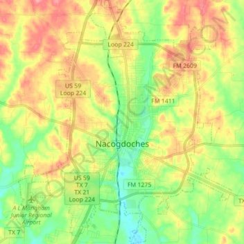
Name: Nacogdoches topographic map, elevation, terrain.

Location: Nacogdoches, Nacogdoches County, Texas, United States (31.55475 -94.71686 31.67345 -94.59344)

Average elevation: 371 ft

Minimum elevation: 230 ft

Maximum elevation: 538 ft

Nacogdoches County trails, hiking, mountain biking, running and outdoor activities

Other topographic maps

Click on a map to view its topography, its elevation and its terrain.
Douglass

United States > Texas > Nacogdoches County

Average elevation: 341 ft

Etoile

United States > Texas > Nacogdoches County

Average elevation: 210 ft

Martinsville

United States > Texas > Nacogdoches County

Average elevation: 285 ft

Orton Hill

United States > Texas > Nacogdoches County > Nacogdoches

Average elevation: 341 ft

Linn Flat

United States > Texas > Nacogdoches County

Average elevation: 413 ft

Martinsville

United States > Texas > Nacogdoches County

Average elevation: 285 ft

Gear up for your next adventure:

🔌USB Car Charger - Car charger for on‑the‑go power needs
🌲Outdoor Survival Books - Best books on survival skills
📱Solar Portable Charger - Solar power bank for charging devices off‑grid
🎒Day Hiking Backpack - Lightweight backpack perfect for day trips and outdoor adventures
🩳Quick‑Dry Hiking Shorts - Comfortable and quick‑dry shorts for summer hiking

As an Amazon Associate, this site earns from qualifying purchases at no extra cost to you.