Geolocate

Manebhanjyang topographic map

Click on the map to display elevation.

About this map

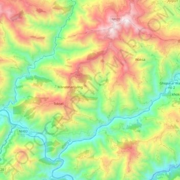
Name: Manebhanjyang topographic map, elevation, terrain.

Location: Manebhanjyang, Okhaldhunga, Koshi Province, Nepal (27.14643 86.37636 27.27727 86.56220)

Average elevation: 3,497 ft

Minimum elevation: 965 ft

Maximum elevation: 7,474 ft

Other topographic maps

Click on a map to view its topography, its elevation and its terrain.

Champadevi

Nepal > Koshi Province > Okhaldhunga

Average elevation: 4,098 ft

Rumjatar

Nepal > Koshi Province > Okhaldhunga

Average elevation: 4,144 ft

Bilandu

Nepal > Koshi Province > Okhaldhunga

Average elevation: 5,292 ft

Gear up for your next adventure:

🛡️Bear Spray Outdoor - Protection in bear country hikes
GPS Sports Watch - GPS watch for running, hiking and training
🪓Survival Multi‑Tool - Versatile tool for camp and trail tasks
🧴Hand Sanitizer - Keep hands clean while hiking
📚Navigation Handbooks - Master the art of reading topographic maps and using a compass

As an Amazon Associate, this site earns from qualifying purchases at no extra cost to you.