
Pimmit Hills topographic map
Click on the map to display elevation.
About this map
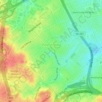
Name: Pimmit Hills topographic map, elevation, terrain.
Location: Pimmit Hills, Fairfax County, Virginia, 22043, United States (38.89899 -77.21555 38.92347 -77.18316)
Average elevation: 367 ft
Minimum elevation: 266 ft
Maximum elevation: 502 ft
Fairfax County trails, hiking, mountain biking, running and outdoor activities
Other topographic maps
Click on a map to view its topography, its elevation and its terrain.
Memorial Heights
United States > Virginia > Fairfax County > Memorial Heights
Average elevation: 125 ft
Cabell's Mill at Ellanor C. Lawerence Park
United States > Virginia > Fairfax County
Average elevation: 318 ft
Salona Village
United States > Virginia > Fairfax County > Langley > Salona Village
Average elevation: 266 ft
Battle of Blackburn's Ford (1861)
United States > Virginia > Fairfax County > Comptons Corner
Average elevation: 197 ft
Belle Haven Park
United States > Virginia > Fairfax County > Alexandria > Westgrove
Average elevation: 26 ft
Madrillon Farms
United States > Virginia > Fairfax County > Tysons > Madrillon Farms
Average elevation: 427 ft
Barkers Crossroads
United States > Virginia > Fairfax County > West Springfield
Average elevation: 236 ft
Great Falls
United States > Virginia > Fairfax County
Great Falls is located at 38°59′53″N 077°17′18″W / 38.99806°N 77.28833°W / 38.99806; -77.28833 (38.9981653, −77.2883157) at an elevation of 344 feet (105 m). Located on Virginia State Route 7 in Northern Virginia, Great Falls is 15 miles (24 km) west-northwest of downtown Washington,…
Average elevation: 295 ft
George Washington's Mount Vernon
United States > Virginia > Fairfax County > Mount Vernon
Average elevation: 46 ft