
Castleton Tower topographic map
Click on the map to display elevation.
About this map
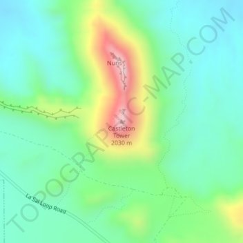
Name: Castleton Tower topographic map, elevation, terrain.
Location: Castleton Tower, Grand County, Utah, United States (38.65122 -109.36795 38.65132 -109.36785)
Average elevation: 5,082 ft
Minimum elevation: 4,577 ft
Maximum elevation: 6,348 ft
Other topographic maps
Click on a map to view its topography, its elevation and its terrain.
Moab
United States > Utah > Grand County
Moab is just south of the Colorado River, at an elevation of 4,025 feet (1,227 m) on the Colorado Plateau. It is 18 miles (29 km) west of the Utah/Colorado state line. Via U.S. Route 191, it is 31 miles (50 km) south of Interstate 70 at Crescent Junction, and it is 54 miles (87 km) north of Monticello. Via…
Average elevation: 4,452 ft
Arches National Park
United States > Utah > Grand County
The park consists of 310.31 square kilometres (76,680 acres; 119.81 sq mi; 31,031 ha) of high desert located on the Colorado Plateau. The highest elevation in the park is 5,653 feet (1,723 m) at Elephant Butte, and the lowest elevation is 4,085 feet (1,245 m) at the visitor center. The park receives an average…
Average elevation: 4,843 ft
Delicate Arch
United States > Utah > Grand County
Delicate Arch is one of the main tourist draws in Arches National Park. The parking lot at the Delicate Arch Trailhead, although large, fills up quickly on most days. The trail to Delicate Arch is 3 miles (4.8 kilometer) round trip with an elevation change of 480 feet (146 meters). The trail is well defined…
Average elevation: 4,623 ft
Moab
United States > Utah > Grand County
Moab is just south of the Colorado River, at an elevation of 4,025 feet (1,227 m) on the Colorado Plateau. It is 18 miles (29 km) west of the Utah/Colorado state line. Via U.S. Route 191, it is 31 miles (50 km) south of Interstate 70 at Crescent Junction, and it is 54 miles (87 km) north of Monticello. Via…
Average elevation: 4,452 ft
Arches National Park
United States > Utah > Grand County
The park consists of 310.31 square kilometres (76,680 acres; 119.81 sq mi; 31,031 ha) of high desert located on the Colorado Plateau. The highest elevation in the park is 5,653 feet (1,723 m) at Elephant Butte, and the lowest elevation is 4,085 feet (1,245 m) at the visitor center. The park receives an average…
Average elevation: 4,843 ft
Arches National Park
United States > Utah > Grand County
The park consists of 310.31 km2 (76,680 acres; 119.81 sq mi; 31,031 ha) of high desert located on the Colorado Plateau. The highest elevation in the park is 5,653 ft (1,723 m) at Elephant Butte, and the lowest elevation is 4,085 ft (1,245 m) at the visitor center. The park receives an average of less than 10…
Average elevation: 4,843 ft
Moab
United States > Utah > Grand County
Moab is just south of the Colorado River, at an elevation of 4,025 feet (1,227 m) on the Colorado Plateau. It is 18 miles (29 km) west of the Utah/Colorado state line. Via U.S. Route 191, it is 31 miles (50 km) south of Interstate 70 at Crescent Junction, and it is 54 miles (87 km) north of Monticello. Via…
Average elevation: 4,452 ft
Delicate Arch
United States > Utah > Grand County
Delicate Arch is one of the main tourist draws in Arches National Park. The parking lot at the Delicate Arch Trailhead, although large, fills up quickly on most days. The trail to Delicate Arch is 3 miles (4.8 kilometer) round trip with an elevation change of 480 feet (146 meters). The trail is well defined…
Average elevation: 4,623 ft