
Moab topographic map
Click on the map to display elevation.
Moab
Moab is just south of the Colorado River, at an elevation of 4,025 feet (1,227 m) on the Colorado Plateau. It is 18 miles (29 km) west of the Utah/Colorado state line. Via U.S. Route 191, it is 31 miles (50 km) south of Interstate 70 at Crescent Junction, and it is 54 miles (87 km) north of Monticello. Via Utah State Route 128 it is 46 miles (74 km) southwest of Cisco. The entrance to Arches National Park is 4 miles (6 km) north of Moab on US 191. Hurrah Pass is located on the trail between Moab and Chicken Corners.
About this map
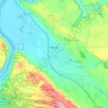
Name: Moab topographic map, elevation, terrain.
Location: Moab, Grand County, Utah, 84532, United States (38.53621 -109.57965 38.60318 -109.51532)
Average elevation: 4,452 ft
Minimum elevation: 3,937 ft
Maximum elevation: 5,728 ft
Grand County trails, hiking, mountain biking, running and outdoor activities
Other topographic maps
Click on a map to view its topography, its elevation and its terrain.