
Fintry topographic map
Click on the map to display elevation.
About this map
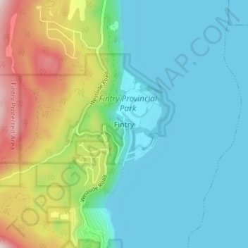
Name: Fintry topographic map, elevation, terrain.
Average elevation: 1,434 ft
Minimum elevation: 1,112 ft
Maximum elevation: 2,369 ft
Other topographic maps
Click on a map to view its topography, its elevation and its terrain.
Lambly Lake
Canada > British Columbia > Regional District of Central Okanagan > West Central Okanagan Electoral Area
Average elevation: 3,983 ft
Christie Lake
Canada > British Columbia > Regional District of Central Okanagan > West Central Okanagan Electoral Area
Average elevation: 4,751 ft