
Make a donation
Gear up for your next adventure:
As an Amazon Associate, this site earns from qualifying purchases at no extra cost to you.
Gilan Province topographic map
Click on the map to display elevation.
Make a donation
Gear up for your next adventure:
As an Amazon Associate, this site earns from qualifying purchases at no extra cost to you.
About this map
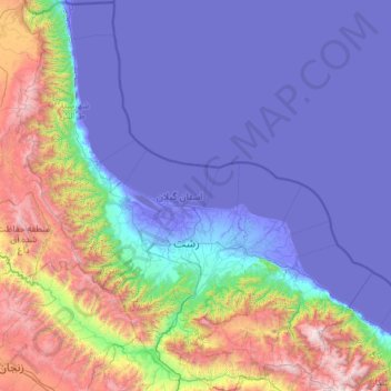
Name: Gilan Province topographic map, elevation, terrain.
Location: Gilan Province, Iran (36.55040 48.53618 38.46034 50.73154)
Average elevation: 1,939 ft
Minimum elevation: -102 ft
Maximum elevation: 12,323 ft
Make a donation
Gear up for your next adventure:
As an Amazon Associate, this site earns from qualifying purchases at no extra cost to you.
Other topographic maps
Click on a map to view its topography, its elevation and its terrain.
Zagros Mountains
Iran > Isfahan Province > Semirom County > Padena-ye Vosta RD
Average elevation: 12,618 ft
Make a donation
Gear up for your next adventure:
As an Amazon Associate, this site earns from qualifying purchases at no extra cost to you.
Damavand
Iran > Mazandaran Province > Amol County > دهستان لاریجان سفلی
Mount Damavand (Persian: دماوند [dæmɒːˈvænd] English: /dɔːmoʊˈvænd/ Da-moh-VAND) is a dormant stratovolcano in Iran. It is the highest peak in Iran and Western Asia, the highest volcano in Asia, and the 3rd highest volcano in the Eastern Hemisphere (after Mount Kilimanjaro and Mount Elbrus), at…
Average elevation: 16,237 ft
Zagros Mountains
Iran > Isfahan Province > Semirom County > Padena-ye Vosta RD
Average elevation: 12,618 ft
Make a donation
Gear up for your next adventure:
As an Amazon Associate, this site earns from qualifying purchases at no extra cost to you.
Iranian plateau
Iran > South Khorasan Province > Tabas County > دهستان دیهوک
The northwestern Iranian plateau, where the Pontic and Taurus Mountains converge, is rugged country with higher elevations, a more severe climate, and greater precipitation than are found on the Anatolian plateau. The region is known as the Anti-Taurus, and the average elevation of its peaks exceeds 3,000 m…
Average elevation: 3,481 ft
Danesfahan
Iran > Qazvin Province > Buin Zahra County > دهستان رامند جنوبی
Average elevation: 4,409 ft
Make a donation
Gear up for your next adventure:
As an Amazon Associate, this site earns from qualifying purchases at no extra cost to you.
Soltanabad-e Tanbali
Iran > Kurdistan Province > Bijar County > دهستان نجف آباد
Average elevation: 6,650 ft
Make a donation
Gear up for your next adventure:
As an Amazon Associate, this site earns from qualifying purchases at no extra cost to you.
Make a donation
Gear up for your next adventure:
As an Amazon Associate, this site earns from qualifying purchases at no extra cost to you.
Taftan
Iran > Sistan and Baluchestan Province > Mirjaveh County > دهستان تمین
Taftan is the highest mountain in southeast Iran. The topography is overall steep. Deep valleys with U and V shapes have developed on Taftan, and the volcano has a strongly eroded appearance. One of these valleys, Tamindan, may be the Damindan valley in the Avesta religious texts. One series of ignimbrites…
Average elevation: 11,565 ft
Band-e Amir
Iran > Fars Province > Zarghan County > Band-e Amir Rural District
Average elevation: 5,243 ft
Make a donation
Gear up for your next adventure:
As an Amazon Associate, this site earns from qualifying purchases at no extra cost to you.
Make a donation
Gear up for your next adventure:
As an Amazon Associate, this site earns from qualifying purchases at no extra cost to you.
Amlash
Iran > Gilan Province > Amlash County > دهستان املش شمالی
Amlash (Persian: املش) is a city in the Central District of Amlash County, Gilan province, in northwestern Iran, serving as the capital of both the county and the district. Amlash sits at an altitude of 13 metres (45 feet).
Average elevation: 217 ft
Make a donation
Gear up for your next adventure:
As an Amazon Associate, this site earns from qualifying purchases at no extra cost to you.
Anbar sar
Iran > Gilan Province > Astaneh-ye Ashrafiyeh County > دهستان دهگاه
Average elevation: -82 ft
Make a donation
Gear up for your next adventure:
As an Amazon Associate, this site earns from qualifying purchases at no extra cost to you.
Nehbandan
Iran > South Khorasan Province > Nehbandan County > دهستان نه
Nehbandan is located at an altitude of 1196 meters above sea level, and the heights of the north of this city reach 2500 meters above sea level. Nehbandan is located near the central desert of Iran. Precious stones in mines along with agriculture is another reason for the importance of Nehbandan. The people of…
Average elevation: 3,967 ft
سیوه کده سفلی
Iran > West Azerbaijan Province > Piranshahr County > دهستان لاهیجان شرقی
Average elevation: 6,490 ft
Make a donation
Gear up for your next adventure:
As an Amazon Associate, this site earns from qualifying purchases at no extra cost to you.
Make a donation
Gear up for your next adventure:
As an Amazon Associate, this site earns from qualifying purchases at no extra cost to you.
Khalifan, Mahabad
Iran > West Azerbaijan Province > Mahabad County > دهستان کانی بازار
Average elevation: 5,112 ft
Make a donation
Gear up for your next adventure:
As an Amazon Associate, this site earns from qualifying purchases at no extra cost to you.
Suran
Iran > Sistan and Baluchestan Province > Sib and Suran County > دهستان سیب وسوران
Average elevation: 3,796 ft
Pardisan Park
Iran > Sistan and Baluchestan Province > Zahedan County > Zahedan
Average elevation: 4,593 ft
Make a donation
Gear up for your next adventure:
As an Amazon Associate, this site earns from qualifying purchases at no extra cost to you.
عزیزآباد پایین
Iran > Sistan and Baluchestan Province > Konarak County > دهستان تنگ
Average elevation: 30 ft
Make a donation
Gear up for your next adventure:
As an Amazon Associate, this site earns from qualifying purchases at no extra cost to you.
Make a donation
Gear up for your next adventure:
As an Amazon Associate, this site earns from qualifying purchases at no extra cost to you.
لواسان بزرگ
Iran > Tehran Province > Shemiranat County > دهستان لواسان بزرگ
Average elevation: 7,733 ft
East Azarbaijan
The highest point in East Azerbaijan is the volcanic peak of Sahand Mountain at 3,707 m (12,162 ft) of elevation, lying south of Tabriz, whereas the lower-lying areas are around Garmadooz (Ahar). The hills and mountains of the province are divided into three ranges: the Qara Daq Mountains, the Sahand and…
Average elevation: 4,098 ft
Natanz
Iran > Isfahan Province > Natanz County > دهستان کرکس
Natanz is located 120 km northeast of Isfahan and on the main north-south highway of Iran. Its altitude is 1666 meters above sea level. The distance between Tehran and Natanz is 326 km, and it takes about 4 hours by car. The Karkas mountain chain (Kuh-e Karkas) (meaning mountain of vultures), at an elevation…
Average elevation: 5,823 ft
Kur Gaz-e Bala
Iran > South Khorasan Province > Birjand County > دهستان القورات
Average elevation: 6,106 ft
Make a donation
Gear up for your next adventure:
As an Amazon Associate, this site earns from qualifying purchases at no extra cost to you.
Make a donation
Gear up for your next adventure:
As an Amazon Associate, this site earns from qualifying purchases at no extra cost to you.
Gangachin
Iran > West Azerbaijan Province > Urumia County > دهستان برادوست
Average elevation: 5,194 ft
Make a donation
Gear up for your next adventure:
As an Amazon Associate, this site earns from qualifying purchases at no extra cost to you.
Make a donation
Gear up for your next adventure:
As an Amazon Associate, this site earns from qualifying purchases at no extra cost to you.
Make a donation
Gear up for your next adventure:
As an Amazon Associate, this site earns from qualifying purchases at no extra cost to you.
Make a donation
Gear up for your next adventure:
As an Amazon Associate, this site earns from qualifying purchases at no extra cost to you.
Make a donation
Gear up for your next adventure:
As an Amazon Associate, this site earns from qualifying purchases at no extra cost to you.
Make a donation
Gear up for your next adventure:
As an Amazon Associate, this site earns from qualifying purchases at no extra cost to you.
Kermanshah
The province's capital is Kermanshah, located in the middle of the western part of Iran. The population of the city is 946,651 as of 2016. It is built on the slopes of Mt. Sefid Kooh and extended toward south during last two decades. The built-up areas run alongside Sarab River and Sarab Valley. The city's…
Average elevation: 3,458 ft
Make a donation
Gear up for your next adventure:
As an Amazon Associate, this site earns from qualifying purchases at no extra cost to you.
Mozdooran Cave
Iran > Razavi Khorasan > Sarakhs County > دهستان مرزداران > Mazdavand
Average elevation: 3,202 ft
Make a donation
Gear up for your next adventure:
As an Amazon Associate, this site earns from qualifying purchases at no extra cost to you.