
Mount Rogers topographic map
Click on the map to display elevation.
Mount Rogers
Mount Rogers is the highest natural point in Virginia, United States, with a summit elevation of 5,729 ft (1,746 m) above mean sea level. The summit straddles the border of Grayson and Smyth Counties, Virginia, about 6.45 mi (10.38 km) WSW of Troutdale, Virginia. Most of the mountain is contained within the Lewis Fork Wilderness, while the entire area is part of the Mount Rogers National Recreation Area, which itself is a part of the Jefferson National Forest.
About this map
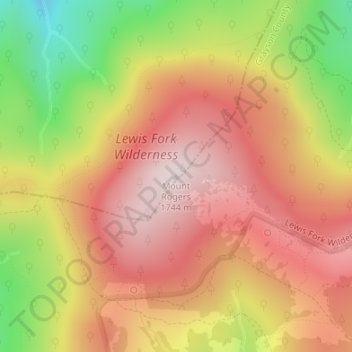
Name: Mount Rogers topographic map, elevation, terrain.
Location: Mount Rogers, Smyth County, Virginia, United States (36.65979 -81.54461 36.65989 -81.54451)
Average elevation: 4,944 ft
Minimum elevation: 3,871 ft
Maximum elevation: 5,682 ft
Smyth County trails, hiking, mountain biking, running and outdoor activities
Other topographic maps
Click on a map to view its topography, its elevation and its terrain.