Geolocate

Middle Head topographic map

Click on the map to display elevation.

About this map

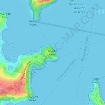
Name: Middle Head topographic map, elevation, terrain.

Location: Middle Head, Mosman, Lower North Shore, Sydney, Mosman Municipal Council, New South Wales, 2088, Australia (-33.82582 151.26709 -33.82572 151.26719)

Average elevation: 30 ft

Minimum elevation: -7 ft

Maximum elevation: 305 ft

Other topographic maps

Click on a map to view its topography, its elevation and its terrain.

Lane Cove National Park

Australia > New South Wales > Sydney

The park includes areas of land which are part of Ku-ring-gai, Ryde, and Hornsby local government areas with small areas of the park in Willoughby, Lane Cove and Hunter's Hill local government areas on the banks of the lower reaches of the river. The park is surrounded on all sides by developed suburban areas…

Average elevation: 266 ft

Palm Beach

Australia > New South Wales > Sydney

Average elevation: 43 ft

East Hills

Australia > New South Wales > Sydney

Average elevation: 49 ft

Sydney

Australia > New South Wales > Sydney

Average elevation: 75 ft

Castle Hill

Australia > New South Wales > Sydney

Average elevation: 404 ft

Hornsby

Australia > New South Wales > Sydney

Average elevation: 525 ft

Penrith

Australia > New South Wales > Sydney > Penrith

Penrith is a city in New South Wales, Australia, located in Greater Western Sydney, 55 kilometres (31 mi) west of the Sydney central business district on the banks of the Nepean River, on the outskirts of the Cumberland Plain. Its elevation is 32 metres (105 ft).

Average elevation: 112 ft

Mount Colah

Australia > New South Wales > Sydney

Mount Colah is 5 km north of Hornsby, the nearest major town centre. It is one of the most northerly suburbs of Sydney and is where the "Welcome to Sydney" sign is located. Mount Colah is the second highest suburb in Sydney by elevation. Considered one of Sydney's leafier suburbs, streets are clustered around…

Average elevation: 499 ft

Lane Cove

Australia > New South Wales > Sydney

Average elevation: 171 ft

Northern Beaches

Australia > New South Wales > Sydney

Average elevation: 220 ft

Macquarie Park

Australia > New South Wales > Sydney

Average elevation: 194 ft

Kensington

Australia > New South Wales > Sydney

Average elevation: 102 ft

Rozelle

Australia > New South Wales > Sydney

Average elevation: 52 ft

Balmain

Australia > New South Wales > Sydney

Average elevation: 39 ft

Manly Vale

Australia > New South Wales > Sydney

Average elevation: 112 ft

Berowra

Australia > New South Wales > Sydney

Berowra is located 44 kilometres north of the Sydney CBD and lies at an altitude of 215 metres. Surrounded by bushland, it borders the national parks of both the Berowra Valley and Ku-ring-gai Chase.

Average elevation: 472 ft

Windsor

Australia > New South Wales > Sydney

Average elevation: 39 ft

Narrabeen

Australia > New South Wales > Sydney

Average elevation: 56 ft

Oatley

Australia > New South Wales > Sydney

Average elevation: 79 ft

Marsden Park

Australia > New South Wales > Sydney

Average elevation: 102 ft

Sydney Park

Australia > New South Wales > Sydney

Average elevation: 43 ft

North Bondi

Australia > New South Wales > Sydney

Average elevation: 72 ft

Blacktown

Australia > New South Wales > Sydney

Average elevation: 187 ft

Strathfield

Australia > New South Wales > Sydney

Average elevation: 85 ft

Auburn

Australia > New South Wales > Sydney

Average elevation: 69 ft

Inner West

Australia > New South Wales > Sydney

Average elevation: 62 ft

Cronulla Beach

Australia > New South Wales > Sydney

Average elevation: 30 ft

Enmore

Australia > New South Wales > Sydney

Average elevation: 75 ft

Heathcote

Australia > New South Wales > Sydney

Average elevation: 486 ft

Terrey Hills

Australia > New South Wales > Sydney

Owing to its elevation and close proximity to the ocean, as well as its extensive tree canopy cover, the weather station at Terrey Hills records the mildest temperatures of any weather station in the Greater Sydney region. Under Köppen's scheme, the suburb has a borderline humid subtropical (Cfa) and oceanic…

Average elevation: 479 ft

Kurrajong Heights

Australia > New South Wales > Sydney

Average elevation: 1,263 ft

Northbridge

Australia > New South Wales > Sydney

Average elevation: 174 ft

Wentworth Falls

Australia > New South Wales > Sydney

Wentworth Falls (postcode: 2782) is a town in the Blue Mountains region of New South Wales, situated approximately 100 kilometres (62 mi) west of the Sydney central business district, and about 8 kilometres (5.0 mi) east of Katoomba, Australia on the Great Western Highway, with a Wentworth Falls railway…

Average elevation: 2,323 ft

North Sydney

Australia > New South Wales > Sydney

Average elevation: 164 ft

Smithfield

Australia > New South Wales > Sydney

Established in 1836, Smithfield was the first major settlement of the Fairfield LGA. The original 1838 summary plan of Smithfield shows the suburb laid out in a grid pattern with most of the streets having the same names as they do today. Its altitude ranges from 21 to 48 m (69 to 157 ft) above sea level.…

Average elevation: 108 ft

Darlinghurst

Australia > New South Wales > Sydney

Average elevation: 125 ft

Carlingford

Australia > New South Wales > Sydney

Average elevation: 322 ft

Killara

Australia > New South Wales > Sydney

Average elevation: 282 ft

North Ryde

Australia > New South Wales > Sydney

Average elevation: 171 ft

Meadowbank

Australia > New South Wales > Sydney

Average elevation: 62 ft

The Ponds

Australia > New South Wales > Sydney

Average elevation: 197 ft

Putney

Australia > New South Wales > Sydney

Average elevation: 59 ft

Dover Heights

Australia > New South Wales > Sydney

Average elevation: 66 ft

Belrose

Australia > New South Wales > Sydney

Average elevation: 407 ft

Barangaroo

Australia > New South Wales > Sydney

Average elevation: 49 ft

Balgowlah

Australia > New South Wales > Sydney

Average elevation: 131 ft

Neutral Bay

Australia > New South Wales > Sydney

Average elevation: 174 ft

Marrickville

Australia > New South Wales > Sydney

Average elevation: 56 ft

Lidcombe

Australia > New South Wales > Sydney

Average elevation: 82 ft

Lane Cove River

Australia > New South Wales > Sydney

Average elevation: 505 ft

Ku-ring-gai Chase National Park

Australia > New South Wales > Sydney

Ku-ring-gai Chase is part of the Hornsby Plateau, a massive block of sandstone tilting upwards to the north. The park comprises a plateau with an elevation of generally 150–200 m above sea level. Between 250 and 200 million years ago, sand silt and mud was deposited by rivers across flood plains. These…

Average elevation: 272 ft

Kingsford

Australia > New South Wales > Sydney

Average elevation: 105 ft

Queens Park

Australia > New South Wales > Sydney

Average elevation: 213 ft

Upper North Shore

Australia > New South Wales > Sydney

Average elevation: 390 ft

South Turramurra

Australia > New South Wales > Sydney

Average elevation: 276 ft

Leonay

Australia > New South Wales > Sydney

Average elevation: 207 ft

Manly Dam

Australia > New South Wales > Sydney

Average elevation: 167 ft

Eastern Suburbs

Australia > New South Wales > Sydney

Average elevation: 43 ft

Wedderburn

Australia > New South Wales > Sydney

Average elevation: 692 ft

Melonba

Australia > New South Wales > Sydney

Average elevation: 66 ft

Wyatt Park

Australia > New South Wales > Sydney

Average elevation: 66 ft

Scotland Island

Australia > New South Wales > Sydney

Average elevation: 56 ft

Woodford

Australia > New South Wales > Sydney

Woodford is a village in the Blue Mountains in New South Wales, Australia, about 90 kilometres west of Sydney. Its elevation is 609 metres (1,998 ft) above sea level. It is situated on the Great Western Highway and has a railway station (opened in 1868 as Buss's Platform) on the Main Western railway line…

Average elevation: 1,785 ft

Hurstville

Australia > New South Wales > Sydney

Average elevation: 164 ft

Rockdale

Australia > New South Wales > Sydney

Average elevation: 66 ft

Wicks Park

Australia > New South Wales > Sydney

Average elevation: 56 ft

Bella Vista

Australia > New South Wales > Sydney

Average elevation: 259 ft

Waverton

Australia > New South Wales > Sydney

Average elevation: 108 ft

Berkshire Park

Australia > New South Wales > Sydney

Average elevation: 89 ft

St Leonards

Australia > New South Wales > Sydney

Average elevation: 226 ft

Meadowbank Park

Australia > New South Wales > Sydney

Average elevation: 46 ft

Denistone West

Australia > New South Wales > Sydney

Average elevation: 180 ft

Nelson

Australia > New South Wales > Sydney

Average elevation: 154 ft

Beaconsfield

Australia > New South Wales > Sydney

Average elevation: 59 ft

Beaman Park

Australia > New South Wales > Sydney

Average elevation: 75 ft

Browns Waterhole

Australia > New South Wales > Sydney

Average elevation: 240 ft

Holroyd

Australia > New South Wales > Sydney

Average elevation: 79 ft

Valley Reserve

Australia > New South Wales > Sydney > Campbelltown

Average elevation: 335 ft

Richmond Lowlands

Australia > New South Wales > Sydney

Average elevation: 43 ft

Oyster Bay

Australia > New South Wales > Sydney

Average elevation: 82 ft

Killarney Heights

Australia > New South Wales > Sydney

Average elevation: 236 ft

North Curl Curl

Australia > New South Wales > Sydney

Average elevation: 72 ft

Sans Souci

Australia > New South Wales > Sydney

Average elevation: 13 ft

Mosman

Australia > New South Wales > Sydney

Average elevation: 95 ft

Marsfield

Australia > New South Wales > Sydney

Average elevation: 236 ft

Gregory Hills

Australia > New South Wales > Sydney

Gregory Hills is a suburb of Sydney in the state of New South Wales, Australia in Camden Council. The suburb was assigned on 1 August 2008. The suburb was named from the topography of the local area and from the original St Gregory's Chapel on the Marist Brothers land.

Average elevation: 358 ft

Oran Park

Australia > New South Wales > Sydney

Average elevation: 305 ft

Schofields

Australia > New South Wales > Sydney

Average elevation: 105 ft

Moorebank

Australia > New South Wales > Sydney

Average elevation: 39 ft

Greystanes

Australia > New South Wales > Sydney

Average elevation: 174 ft

Cammeray

Australia > New South Wales > Sydney

Prior to the 1920s, the suburb was known as Suspension Bridge reflecting the now Long Gully Bridge that joined Northbridge to Cammeray. Cammeray was slow to develop mainly due to its steep topography and remoteness from transport.

Average elevation: 217 ft

Bringelly

Australia > New South Wales > Sydney

Average elevation: 285 ft

Crows Nest

Australia > New South Wales > Sydney

Average elevation: 223 ft

Londonderry

Australia > New South Wales > Sydney

Average elevation: 95 ft

Annandale

Australia > New South Wales > Sydney

Average elevation: 79 ft

Randwick

Australia > New South Wales > Sydney

Average elevation: 144 ft

Leichhardt

Australia > New South Wales > Sydney

Average elevation: 72 ft

Gear up for your next adventure:

🧭GPS Watch Accessories - Bands and chargers for GPS watches
🦟Ultrasonic Repellers - Create a bug-free zone at your camp or rest stop
🧭Pro Hiking Compasses - High-accuracy liquid-filled compasses for topographic orientation
📱Solar Portable Charger - Solar power bank for charging devices off‑grid
📱Heavy-Duty Phone Cases - Drop-proof and waterproof protection for outdoor navigation

As an Amazon Associate, this site earns from qualifying purchases at no extra cost to you.