Make a donation
Gear up for your next adventure:
As an Amazon Associate, this site earns from qualifying purchases at no extra cost to you.
Mattingley topographic map
Click on the map to display elevation.
Make a donation
Gear up for your next adventure:
As an Amazon Associate, this site earns from qualifying purchases at no extra cost to you.
About this map
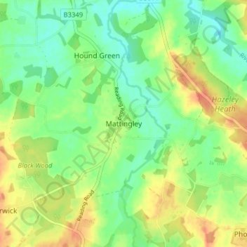
Name: Mattingley topographic map, elevation, terrain.
Location: Mattingley, Hart, Hampshire, England, RG27 8JY, United Kingdom (51.29543 -0.96724 51.33543 -0.92724)
Average elevation: 213 ft
Minimum elevation: 154 ft
Maximum elevation: 282 ft
Make a donation
Gear up for your next adventure:
As an Amazon Associate, this site earns from qualifying purchases at no extra cost to you.
Other topographic maps
Click on a map to view its topography, its elevation and its terrain.
Make a donation
Gear up for your next adventure:
As an Amazon Associate, this site earns from qualifying purchases at no extra cost to you.
Make a donation
Gear up for your next adventure:
As an Amazon Associate, this site earns from qualifying purchases at no extra cost to you.
Make a donation
Gear up for your next adventure:
As an Amazon Associate, this site earns from qualifying purchases at no extra cost to you.
Hartley Wintney
United Kingdom > England > Hampshire > Hart > Hartley Wintney
Average elevation: 243 ft
Crookham Village
United Kingdom > England > Hampshire > Hart > Crookham Village
Average elevation: 266 ft
Make a donation
Gear up for your next adventure:
As an Amazon Associate, this site earns from qualifying purchases at no extra cost to you.
