Geolocate

Hampton topographic map

Click on the map to display elevation.

About this map

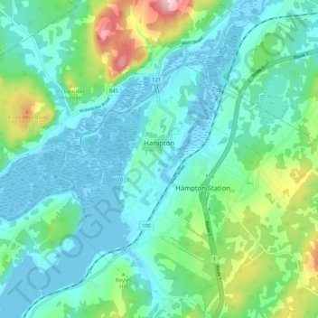
Name: Hampton topographic map, elevation, terrain.

Location: Hampton, Hampton Parish, Kings County, New Brunswick, Canada (45.49152 -65.90581 45.56224 -65.80219)

Average elevation: 157 ft

Minimum elevation: -16 ft

Maximum elevation: 722 ft

Other topographic maps

Click on a map to view its topography, its elevation and its terrain.

Hampton Station

Canada > New Brunswick > Hampton Parish

Average elevation: 184 ft

Gear up for your next adventure:

📶Satellite Messenger - Communication device off‑grid
🎒Outdoor Daypacks - Lightweight backpacks designed for carrying maps and essential gear
🗃️Trail First Aid Kit - Essential kit for outdoor injuries and emergencies
🧭Hiking Compass - Precision compass for reliable navigation in the wilderness
🔭Telescopic Hiking Pole - Adjustable pole for hiking stability

As an Amazon Associate, this site earns from qualifying purchases at no extra cost to you.