Geolocate

Brooks topographic map

Click on the map to display elevation.

About this map

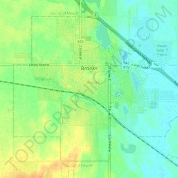
Name: Brooks topographic map, elevation, terrain.

Location: Brooks, City of Brooks, Alberta, Canada (50.54286 -111.92915 50.58660 -111.84309)

Average elevation: 2,487 ft

Minimum elevation: 2,444 ft

Maximum elevation: 2,549 ft

Gear up for your next adventure:

⛑️Personal Locator Beacon - Safety beacon for emergencies
🔦Powerful Headlamps - Ultra-bright hands-free lighting for night navigation
📚Navigation Handbooks - Master the art of reading topographic maps and using a compass
🏕️Tent Footprint - Protect your tent base from wear
🛰️Handheld GPS Units - Professional satellite navigators for precise backcountry mapping

As an Amazon Associate, this site earns from qualifying purchases at no extra cost to you.