
Make a donation
Gear up for your next adventure:
As an Amazon Associate, this site earns from qualifying purchases at no extra cost to you.
Cogon topographic map
Click on the map to display elevation.
Make a donation
Gear up for your next adventure:
As an Amazon Associate, this site earns from qualifying purchases at no extra cost to you.
About this map
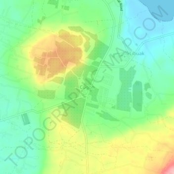
Name: Cogon topographic map, elevation, terrain.
Location: Cogon, Davao del Norte, Davao Region, 8118, Philippines (7.13234 125.69709 7.17234 125.73709)
Average elevation: 177 ft
Minimum elevation: 0 ft
Maximum elevation: 482 ft
Make a donation
Gear up for your next adventure:
As an Amazon Associate, this site earns from qualifying purchases at no extra cost to you.
Other topographic maps
Click on a map to view its topography, its elevation and its terrain.
Make a donation
Gear up for your next adventure:
As an Amazon Associate, this site earns from qualifying purchases at no extra cost to you.
Faith Tabernacle Church Sto. Tomas
Philippines > Davao del Norte > Santo Tomas
Average elevation: 118 ft