
Garissa topographic map
Click on the map to display elevation.
Garissa
Garissa has a hot arid climate (Köppen climate classification BWh), despite receiving around 375 millimetres or 15 inches of rainfall per year, due to the extremely high potential evapotranspiration. Garissa's landscape is mostly arid, desert terrain. The city lies along the Tana River, and has a hot climate due to the low elevation and distance from cooler coastal areas. The daytime temperature typically rises above 33 °C or 91.4 °F every day, but cools down every night.
About this map
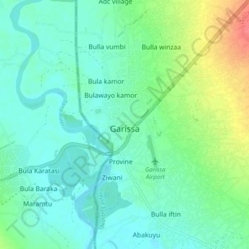
Name: Garissa topographic map, elevation, terrain.
Location: Garissa, Northeast Kenya, Kenya (-0.49057 39.63379 -0.42057 39.67701)
Average elevation: 489 ft
Minimum elevation: 436 ft
Maximum elevation: 640 ft