Geolocate

Peel topographic map

Interactive map

Click on the map to display elevation.

About this map

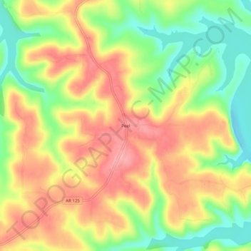
Name: Peel topographic map, elevation, terrain.

Location: Peel, Marion County, Arkansas, 72668, United States (36.41229 -92.78878 36.45229 -92.74878)

Average elevation: 801 ft

Minimum elevation: 614 ft

Maximum elevation: 958 ft

Other topographic maps

Click on a map to view its topography, its elevation and its terrain.

Yellville

United States > Arkansas > Marion County

Yellville, Marion County, Arkansas, 72687, United States

Average elevation: 692 ft

Flippin

United States > Arkansas > Marion County

Flippin, Marion County, Arkansas, 72634, United States

Average elevation: 679 ft

Bull Shoals

United States > Arkansas > Marion County > Bull Shoals

Bull Shoals, Marion County, Arkansas, 72619, United States

Average elevation: 692 ft

Pyatt

United States > Arkansas > Marion County > Pyatt

Pyatt, Marion County, Arkansas, 72672, United States

Average elevation: 853 ft

Oakland

United States > Arkansas > Marion County

Oakland, Marion County, Arkansas, 72661, United States

Average elevation: 850 ft

Bull Shoals

United States > Arkansas > Marion County

Bull Shoals, Marion County, Arkansas, 72619, United States

Average elevation: 692 ft