Geolocate

Lawrence topographic map

Click on the map to display elevation.

About this map

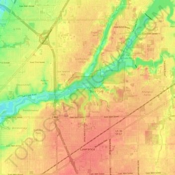
Name: Lawrence topographic map, elevation, terrain.

Location: Lawrence, Marion County, Indiana, United States (39.82776 -86.05550 39.91305 -85.93806)

Average elevation: 833 ft

Minimum elevation: 725 ft

Maximum elevation: 886 ft

Marion County trails, hiking, mountain biking, running and outdoor activities

Other topographic maps

Click on a map to view its topography, its elevation and its terrain.

Sexton Park

United States > Indiana > Marion County > Indianapolis

Average elevation: 719 ft

Hoover Crest

United States > Indiana > Marion County > Indianapolis

Average elevation: 794 ft

Lakeside

United States > Indiana > Marion County > Indianapolis

Average elevation: 843 ft

Ravenswood

United States > Indiana > Marion County > Indianapolis

Average elevation: 748 ft

Mickleyville

United States > Indiana > Marion County > Indianapolis

Average elevation: 761 ft

Vertland

United States > Indiana > Marion County > Indianapolis

Average elevation: 820 ft

Wolfington

United States > Indiana > Marion County > Indianapolis

Average elevation: 755 ft

Gear up for your next adventure:

🪶Survival Guide Book - Expert advice for emergency preparedness
🧢Sun Protection Hats - Wide-brimmed and UPF-rated hats for high-altitude sun safety
🕶️GPS Smartphone Mount - Secure mount for phone navigation
🎒Waterproof Dry Bags - Keep your electronics and maps dry inside your pack
🕶️Glacier Sunglasses - Side shields to protect eyes from high-altitude snow glare

As an Amazon Associate, this site earns from qualifying purchases at no extra cost to you.