
Make a donation
Gear up for your next adventure:
As an Amazon Associate, this site earns from qualifying purchases at no extra cost to you.
Harriston topographic map
Click on the map to display elevation.
Make a donation
Gear up for your next adventure:
As an Amazon Associate, this site earns from qualifying purchases at no extra cost to you.
About this map
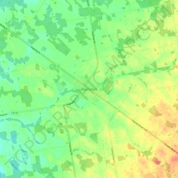
Name: Harriston topographic map, elevation, terrain.
Average elevation: 1,266 ft
Minimum elevation: 1,201 ft
Maximum elevation: 1,355 ft
Make a donation
Gear up for your next adventure:
As an Amazon Associate, this site earns from qualifying purchases at no extra cost to you.
Other topographic maps
Click on a map to view its topography, its elevation and its terrain.
Make a donation
Gear up for your next adventure:
As an Amazon Associate, this site earns from qualifying purchases at no extra cost to you.
Guelph Lake Conservation Area
Canada > Ontario > Wellington County > Guelph
Average elevation: 1,168 ft
Make a donation
Gear up for your next adventure:
As an Amazon Associate, this site earns from qualifying purchases at no extra cost to you.
Belwood Lake Boat Launch
Canada > Ontario > Wellington County > Centre Wellington
Average elevation: 1,453 ft
Guelph Lake
Canada > Ontario > Wellington County > Guelph/Eramosa > Eramosa
Average elevation: 1,165 ft
Make a donation
Gear up for your next adventure:
As an Amazon Associate, this site earns from qualifying purchases at no extra cost to you.
Guelph Lake Conservation Area
Canada > Ontario > Wellington County > Guelph
Average elevation: 1,168 ft