Geolocate

Winesap topographic map

Click on the map to display elevation.

About this map

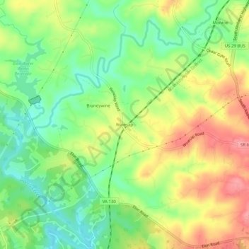
Name: Winesap topographic map, elevation, terrain.

Location: Winesap, Amherst County, Virginia, 24572, United States (37.46570 -79.16725 37.50570 -79.12725)

Average elevation: 741 ft

Minimum elevation: 597 ft

Maximum elevation: 912 ft

Amherst County trails, hiking, mountain biking, running and outdoor activities

Other topographic maps

Click on a map to view its topography, its elevation and its terrain.

Amherst

United States > Virginia > Amherst County

Average elevation: 712 ft

Gear up for your next adventure:

📱Solar Portable Charger - Solar power bank for charging devices off‑grid
👟Men's Trail Runners - Lightweight footwear for fast-paced exploration and light hiking
🛠️Backpacking Tool Kit - Essential toolkit for outdoor repairs
🚁Photography Drones - Capture stunning aerial views of landforms and topography
👟Trail Running Shoes - Lightweight shoes for trail runners

As an Amazon Associate, this site earns from qualifying purchases at no extra cost to you.