
Knights Landing topographic map
Click on the map to display elevation.
About this map
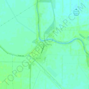
Name: Knights Landing topographic map, elevation, terrain.
Average elevation: 30 ft
Minimum elevation: 13 ft
Maximum elevation: 46 ft
Yolo County trails, hiking, mountain biking, running and outdoor activities
Other topographic maps
Click on a map to view its topography, its elevation and its terrain.
Davis
United States > California > Yolo County
Davis lies in the Sacramento Valley, the northern portion of the Central Valley, in Northern California, at an elevation of about 52 feet (16 m) above sea level.
Average elevation: 46 ft
Guinda
United States > California > Yolo County
Guinda (Spanish for "Sour cherry") is a census-designated place in Yolo County, California. It is located in the Capay Valley, in the northwestern portion of the county, 13 miles (21 km) northwest of Esparto. Guinda's ZIP Code is 95637 and the town is in area code 530. It lies at an elevation of 361 feet (110…
Average elevation: 407 ft
Davis
United States > California > Yolo County
Davis lies in the Sacramento Valley, the northern portion of the Central Valley, in Northern California, at an elevation of about 52 feet (16 m) above sea level.
Average elevation: 46 ft
Davis
United States > California > Yolo County
Davis lies in the Sacramento Valley, the northern portion of the Central Valley, in Northern California, at an elevation of about 52 feet (16 m) above sea level.
Average elevation: 46 ft
Davis
United States > California > Yolo County
Davis lies in the Sacramento Valley, the northern portion of the Central Valley, in Northern California, at an elevation of about 52 feet (16 m) above sea level.
Average elevation: 46 ft
Rumsey
United States > California > Yolo County
Rumsey is an unincorporated community and census-designated place (CDP) in Yolo County, California. It is located 18 miles (29 km) northwest of Esparto, in the Capay Valley, in the northwestern part of the county. Rumsey's ZIP Code is 95679 and its area code 530. It lies at an elevation of 420 feet (128 m).
Average elevation: 636 ft