Geolocate

Tignall topographic map

Click on the map to display elevation.

About this map

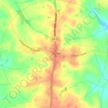
Name: Tignall topographic map, elevation, terrain.

Location: Tignall, Wilkes County, Georgia, United States (33.85318 -82.75882 33.88193 -82.72448)

Average elevation: 591 ft

Minimum elevation: 499 ft

Maximum elevation: 653 ft

Wilkes County trails, hiking, mountain biking, running and outdoor activities

Other topographic maps

Click on a map to view its topography, its elevation and its terrain.

Rayle

United States > Georgia > Wilkes County

Average elevation: 643 ft

Adasburg

United States > Georgia > Wilkes County

Average elevation: 476 ft

Gear up for your next adventure:

👖Convertible Hiking Pants - Versatile zip-off pants for changing altitudes and temperatures
🔭Compact Binoculars - HD vision for scouting terrain and identifying distant landmarks
🪶Camp Gear Gift Set - Perfect gift bundle for outdoor fans
🎒Trekking Poles - Sturdy poles for balance and stability on rough terrain
📚USA Hiking Guide Books - Top trail guides and map books

As an Amazon Associate, this site earns from qualifying purchases at no extra cost to you.