
Escaldes-Engordany topographic map
Interactive map
Click on the map to display elevation.
About this map
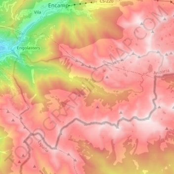
Name: Escaldes-Engordany topographic map, elevation, terrain.
Location: Escaldes-Engordany, AD700, Andorra (42.44989 1.52156 42.52380 1.66329)
Average elevation: 7,329 ft
Minimum elevation: 3,386 ft
Maximum elevation: 9,534 ft
Other topographic maps
Click on a map to view its topography, its elevation and its terrain.
Andorra la Vella
Andorra > Andorra la Vella > Andorra la Vella
Andorra la Vella, AD500, Andorra
Average elevation: 5,315 ft
Andorra la Vella
Andorra > Andorra la Vella > Andorra la Vella
Andorra la Vella, AD500, Andorra
Average elevation: 4,167 ft