
Make a donation
Gear up for your next adventure:
As an Amazon Associate, this site earns from qualifying purchases at no extra cost to you.
Rincão dos Kroeff topographic map
Click on the map to display elevation.
Make a donation
Gear up for your next adventure:
As an Amazon Associate, this site earns from qualifying purchases at no extra cost to you.
About this map
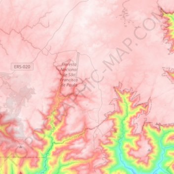
Name: Rincão dos Kroeff topographic map, elevation, terrain.
Average elevation: 2,592 ft
Minimum elevation: 246 ft
Maximum elevation: 3,251 ft
Make a donation
Gear up for your next adventure:
As an Amazon Associate, this site earns from qualifying purchases at no extra cost to you.
Other topographic maps
Click on a map to view its topography, its elevation and its terrain.
Campestre do Tigre
Brasil > Rio Grande do Sul > São Francisco de Paula > Campestre do Tigre
Average elevation: 2,598 ft
Make a donation
Gear up for your next adventure:
As an Amazon Associate, this site earns from qualifying purchases at no extra cost to you.
Cachoeiras Gemeas Gigantes
Brasil > Rio Grande do Sul > São Francisco de Paula
Average elevation: 2,726 ft
Fazenda Baú
Brasil > Rio Grande do Sul > São Francisco de Paula > Fazenda Baú
Average elevation: 2,818 ft
Make a donation
Gear up for your next adventure:
As an Amazon Associate, this site earns from qualifying purchases at no extra cost to you.