Geolocate

Samambaia topographic map

Click on the map to display elevation.

About this map

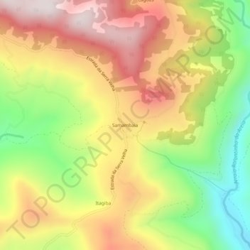
Name: Samambaia topographic map, elevation, terrain.

Location: Samambaia, São Francisco de Paula, Região Geográfica Imediata de Caxias do Sul, Região Geográfica Intermediária de Caxias do Sul, Rio Grande do Sul, Região Sul, Brasil (-29.53215 -50.58320 -29.49215 -50.54320)

Average elevation: 1,870 ft

Minimum elevation: 584 ft

Maximum elevation: 3,064 ft

Other topographic maps

Click on a map to view its topography, its elevation and its terrain.

Tainhas

Brasil > Rio Grande do Sul > São Francisco de Paula

Average elevation: 2,789 ft

Juá

Brasil > Rio Grande do Sul > São Francisco de Paula

Average elevation: 2,785 ft

Eletra

Brasil > Rio Grande do Sul > São Francisco de Paula

Average elevation: 2,789 ft

Gear up for your next adventure:

🥾Men's Hiking Boots - Durable, waterproof footwear for rugged terrain and steep inclines
📱Heavy-Duty Phone Cases - Drop-proof and waterproof protection for outdoor navigation
🪶Paracord Bracelet - Survival bracelet with built‑in tools
👟Men's Trail Runners - Lightweight footwear for fast-paced exploration and light hiking
🕶️GPS Smartphone Mount - Secure mount for phone navigation

As an Amazon Associate, this site earns from qualifying purchases at no extra cost to you.