Geolocate

Warsaw topographic map

Click on the map to display elevation.

About this map

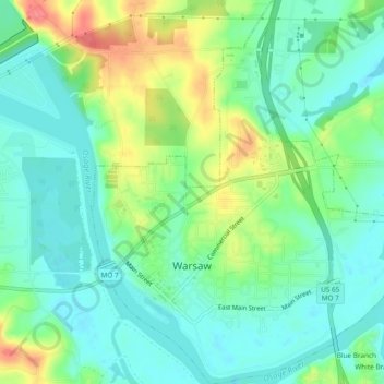
Name: Warsaw topographic map, elevation, terrain.

Location: Warsaw, Benton County, Missouri, United States (38.23278 -93.38987 38.26986 -93.35110)

Average elevation: 715 ft

Minimum elevation: 643 ft

Maximum elevation: 866 ft

Benton County trails, hiking, mountain biking, running and outdoor activities

Other topographic maps

Click on a map to view its topography, its elevation and its terrain.

Brandon

United States > Missouri > Benton County

Average elevation: 922 ft

Edwards

United States > Missouri > Benton County

Average elevation: 850 ft

Palo Pinto

United States > Missouri > Benton County

Average elevation: 833 ft

White Branch

United States > Missouri > Benton County

Average elevation: 738 ft

Gear up for your next adventure:

⛑️Personal Locator Beacon - Safety beacon for emergencies
🏕️Tent Footprint - Protect your tent base from wear
🧺Microfiber Travel Towels - Compact and fast-drying towels for trail use
📡GPS Antenna Upgrade - Enhance GPS reception in remote terrain
🧥Men's Rain Shells - Premium waterproof and breathable jackets for mountain weather

As an Amazon Associate, this site earns from qualifying purchases at no extra cost to you.