
Edneyville topographic map
Click on the map to display elevation.
Edneyville
Edneyville is in northeastern Henderson County at an elevation of 2,246 feet (685 m) above sea level. The Eastern Continental Divide runs through the center of the CDP; the eastern side of the community drains via Reedypatch Creek to the Broad River, which flows through the Congaree and Santee River systems to the Atlantic Ocean, while the western side of the community drains to Clear Creek, which flows via Mud Creek to the French Broad River, then the Tennessee River, and finally the Mississippi River to the Gulf of Mexico.
About this map
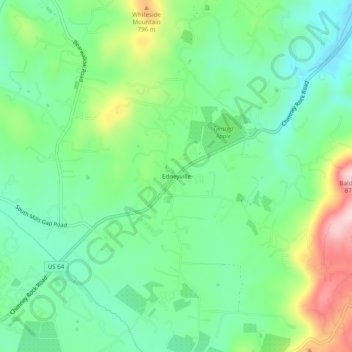
Name: Edneyville topographic map, elevation, terrain.
Location: Edneyville, Henderson County, North Carolina, United States (35.37401 -82.36095 35.41401 -82.32095)
Average elevation: 2,260 ft
Minimum elevation: 1,982 ft
Maximum elevation: 2,851 ft
Henderson County trails, hiking, mountain biking, running and outdoor activities
Other topographic maps
Click on a map to view its topography, its elevation and its terrain.
Etowah
United States > North Carolina > Henderson County
Etowah has an altitude of 2,101 feet (640 m).
Average elevation: 2,139 ft
Hendersonville Reservoir
United States > North Carolina > Henderson County
Average elevation: 2,805 ft
Mills River
United States > North Carolina > Henderson County > Mills River
Average elevation: 2,251 ft
Mills River
United States > North Carolina > Henderson County > Mills River > Oak Hill Court
Average elevation: 2,113 ft