
Sortino topographic map
Interactive map
Click on the map to display elevation.
About this map
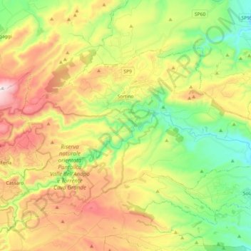
Name: Sortino topographic map, elevation, terrain.
Location: Sortino, Syracuse, Sicile, 96010, Italie (37.09493 14.95185 37.18483 15.13324)
Average elevation: 1,381 ft
Minimum elevation: 302 ft
Maximum elevation: 2,844 ft
Other topographic maps
Click on a map to view its topography, its elevation and its terrain.
Francofonte
Francofonte, Syracuse, Sicile, 96015, Italie
Average elevation: 1,060 ft
Riserva naturale orientata Oasi Faunistica di Vendicari
Italie > Sicile > Syracuse > Noto > San Lorenzo
Riserva naturale orientata Oasi Faunistica di Vendicari, Strada Prima San Lorenzo, San Lorenzo, Noto, Syracuse, Sicile, 96017, Italie
Average elevation: 49 ft