
Melilli topographic map
Interactive map
Click on the map to display elevation.
About this map
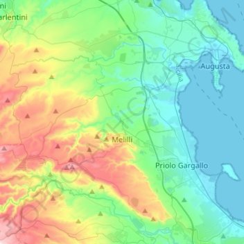
Name: Melilli topographic map, elevation, terrain.
Location: Melilli, Syracuse, Sicile, 96010, Italie (37.09517 14.99785 37.28931 15.23752)
Average elevation: 597 ft
Minimum elevation: -7 ft
Maximum elevation: 2,211 ft
Other topographic maps
Click on a map to view its topography, its elevation and its terrain.
Francofonte
Francofonte, Syracuse, Sicile, 96015, Italie
Average elevation: 1,060 ft
Riserva naturale orientata Oasi Faunistica di Vendicari
Italie > Sicile > Syracuse > Noto > San Lorenzo
Riserva naturale orientata Oasi Faunistica di Vendicari, Strada Prima San Lorenzo, San Lorenzo, Noto, Syracuse, Sicile, 96017, Italie
Average elevation: 49 ft