
Make a donation
Gear up for your next adventure:
As an Amazon Associate, this site earns from qualifying purchases at no extra cost to you.
Reuden topographic map
Click on the map to display elevation.
Make a donation
Gear up for your next adventure:
As an Amazon Associate, this site earns from qualifying purchases at no extra cost to you.
About this map
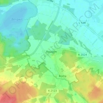
Name: Reuden topographic map, elevation, terrain.
Average elevation: 269 ft
Minimum elevation: 210 ft
Maximum elevation: 400 ft
Make a donation
Gear up for your next adventure:
As an Amazon Associate, this site earns from qualifying purchases at no extra cost to you.
Other topographic maps
Click on a map to view its topography, its elevation and its terrain.
Eutzsch
Deutschland > Sachsen-Anhalt > Wittenberg > Kemberg
Der Ort selber liegt auf einer gegenüber der ihn umgebenden Auenlandschaft maximal 1 Meter höheren Erhebung aus angelagerten Flusssedimenten, die im Verlauf der Geschichte – insbesondere im Umfeld der Dorfkirche und des Friedhofs – möglicherweise zusätzlich künstlich aufgeschüttet wurde. Während…
Average elevation: 220 ft
Make a donation
Gear up for your next adventure:
As an Amazon Associate, this site earns from qualifying purchases at no extra cost to you.