Geolocate

Muldraugh topographic map

Click on the map to display elevation.

About this map

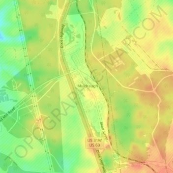
Name: Muldraugh topographic map, elevation, terrain.

Location: Muldraugh, Meade County, Kentucky, 40155, United States (37.92215 -85.99784 37.95152 -85.97936)

Average elevation: 735 ft

Minimum elevation: 646 ft

Maximum elevation: 791 ft

Meade County trails, hiking, mountain biking, running and outdoor activities

Other topographic maps

Click on a map to view its topography, its elevation and its terrain.

Cold Springs

United States > Kentucky > Meade County

Average elevation: 627 ft

Gear up for your next adventure:

🎒Waterproof Dry Bags - Keep your electronics and maps dry inside your pack
🔭Compact Binoculars - HD vision for scouting terrain and identifying distant landmarks
🧯Emergency Survival Kit - All‑in‑one survival essentials for the backcountry
🛠️Outdoor Gear Repair Kit - Essential tools to fix gear on the trail
📶Satellite Messenger - Communication device off‑grid

As an Amazon Associate, this site earns from qualifying purchases at no extra cost to you.