Geolocate

Cold Springs topographic map

Click on the map to display elevation.

About this map

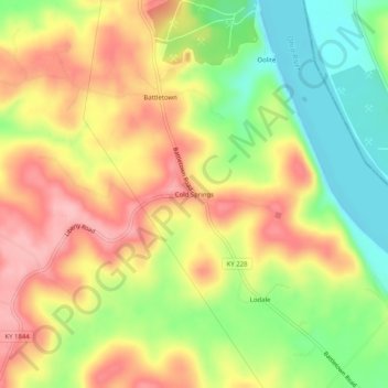
Name: Cold Springs topographic map, elevation, terrain.

Location: Cold Springs, Meade County, Kentucky, 40104, United States (38.03396 -86.30942 38.07396 -86.26942)

Average elevation: 627 ft

Minimum elevation: 381 ft

Maximum elevation: 853 ft

Meade County trails, hiking, mountain biking, running and outdoor activities

Other topographic maps

Click on a map to view its topography, its elevation and its terrain.

Brandenburg

United States > Kentucky > Meade County

Average elevation: 551 ft

Muldraugh

United States > Kentucky > Meade County

Average elevation: 735 ft

Brandenburg

United States > Kentucky > Meade County

Average elevation: 551 ft

Gear up for your next adventure:

🥘Titanium Cookware - Durable, featherlight pots and pans for backpacking
🛌Ultralight Sleeping Bags - Compact down bags for cold nights in the wilderness
🧭Compass with Lanyard - Easy‑carry compass for navigation
Backpacking Tent - Lightweight and durable tent for multi‑day hikes
🧭GPS Watch Accessories - Bands and chargers for GPS watches

As an Amazon Associate, this site earns from qualifying purchases at no extra cost to you.