
Make a donation
Gear up for your next adventure:
As an Amazon Associate, this site earns from qualifying purchases at no extra cost to you.
Mifflin Township topographic map
Click on the map to display elevation.
Make a donation
Gear up for your next adventure:
As an Amazon Associate, this site earns from qualifying purchases at no extra cost to you.
About this map
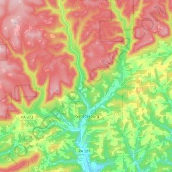
Name: Mifflin Township topographic map, elevation, terrain.
Average elevation: 1,237 ft
Minimum elevation: 551 ft
Maximum elevation: 1,965 ft
Lycoming County trails, hiking, mountain biking, running and outdoor activities
Make a donation
Gear up for your next adventure:
As an Amazon Associate, this site earns from qualifying purchases at no extra cost to you.
Other topographic maps
Click on a map to view its topography, its elevation and its terrain.
Little Pine Creek
United States > Pennsylvania > Lycoming County > Pine Township
Average elevation: 1,430 ft
Susquehanna State Park
United States > Pennsylvania > Lycoming County > Williamsport
Average elevation: 676 ft
Make a donation
Gear up for your next adventure:
As an Amazon Associate, this site earns from qualifying purchases at no extra cost to you.
Steam Valley
United States > Pennsylvania > Lycoming County > Cogan House Township
Average elevation: 1,768 ft
Make a donation
Gear up for your next adventure:
As an Amazon Associate, this site earns from qualifying purchases at no extra cost to you.