
Make a donation
Gear up for your next adventure:
As an Amazon Associate, this site earns from qualifying purchases at no extra cost to you.
Eernegem topographic map
Click on the map to display elevation.
Make a donation
Gear up for your next adventure:
As an Amazon Associate, this site earns from qualifying purchases at no extra cost to you.
Eernegem
Eernegem ligt in Zandig Vlaanderen op een hoogte van 3,5 tot 19 meter, en wel in het Houtland, maar veel bossen zijn er niet meer terug te vinden. In het noorden is een lager moerasgebied te vinden. Wel zijn er in Eernegem twee belangrijke groenzones: de Statieput en de Groene 62. Er zijn diverse beekjes die in noordelijke richting afwateren op de Bourgognevaart of de Moerdijkvaart.
Make a donation
Gear up for your next adventure:
As an Amazon Associate, this site earns from qualifying purchases at no extra cost to you.
About this map
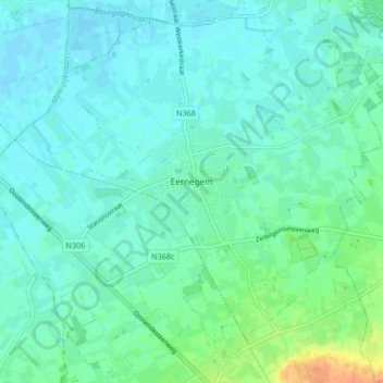
Name: Eernegem topographic map, elevation, terrain.
Average elevation: 26 ft
Minimum elevation: -7 ft
Maximum elevation: 125 ft
Make a donation
Gear up for your next adventure:
As an Amazon Associate, this site earns from qualifying purchases at no extra cost to you.
Other topographic maps
Click on a map to view its topography, its elevation and its terrain.
Make a donation
Gear up for your next adventure:
As an Amazon Associate, this site earns from qualifying purchases at no extra cost to you.
Make a donation
Gear up for your next adventure:
As an Amazon Associate, this site earns from qualifying purchases at no extra cost to you.
Make a donation
Gear up for your next adventure:
As an Amazon Associate, this site earns from qualifying purchases at no extra cost to you.
De Meiboom
België > West-Vlaanderen > Oostende > Oudenburg > Roksem > De Meiboom
Average elevation: 20 ft