Geolocate

Gullfoss topographic map

Click on the map to display elevation.

About this map

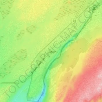
Name: Gullfoss topographic map, elevation, terrain.

Location: Gullfoss, Bláskógabyggð, Southern Region, Iceland (64.30019 -20.16534 64.32894 -20.11838)

Average elevation: 702 ft

Minimum elevation: 410 ft

Maximum elevation: 1,020 ft

Other topographic maps

Click on a map to view its topography, its elevation and its terrain.

Strokkur

Iceland > Bláskógabyggð

Average elevation: 377 ft

Skjaldbreiður

Iceland > Bláskógabyggð

Average elevation: 2,986 ft

Laugarás

Iceland > Bláskógabyggð

Average elevation: 203 ft

Þingvellir National Park

Iceland > Bláskógabyggð

Average elevation: 1,037 ft

Gullfoss Falls

Iceland > Bláskógabyggð

Average elevation: 725 ft

Þingvellir National Park

Iceland > Bláskógabyggð

Average elevation: 1,037 ft

Þingvellir National Park

Iceland > Bláskógabyggð

Average elevation: 1,037 ft

Geysir

Iceland > Bláskógabyggð

Average elevation: 381 ft

Thingvellir

Iceland > Bláskógabyggð

Average elevation: 397 ft

Laugarvatn

Iceland > Bláskógabyggð > Laugarvatn

Average elevation: 220 ft

Skjaldbreiður

Iceland > Bláskógabyggð

Average elevation: 2,986 ft

Gear up for your next adventure:

👓Polarized Sunglasses - Outdoor sunglasses for glare reduction
🪶Compact Camp Shovel - Folding shovel for campsite tasks
🎁Geography Themed Gifts - Unique gift ideas for map lovers and geography enthusiasts
⛑️Personal Locator Beacon - Safety beacon for emergencies
🛰️Satellite Messengers - Emergency SOS and two-way messaging for off-grid adventures

As an Amazon Associate, this site earns from qualifying purchases at no extra cost to you.