
Witney topographic map
Click on the map to display elevation.
About this map
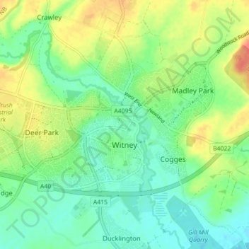
Name: Witney topographic map, elevation, terrain.
Location: Witney, West Oxfordshire, Oxfordshire, England, United Kingdom (51.77532 -1.52759 51.79955 -1.45705)
Average elevation: 302 ft
Minimum elevation: 236 ft
Maximum elevation: 417 ft
Other topographic maps
Click on a map to view its topography, its elevation and its terrain.
Ledwell
United Kingdom > England > Oxfordshire > West Oxfordshire > Sandford St. Martin
Average elevation: 466 ft
Eynsham Mill
United Kingdom > England > Oxfordshire > West Oxfordshire > Eynsham
Average elevation: 233 ft
Shipton-under-Wychwood
United Kingdom > England > Oxfordshire > West Oxfordshire
Average elevation: 430 ft
Great Park
United Kingdom > England > Oxfordshire > West Oxfordshire > Long Hanborough
Average elevation: 308 ft
Upper Milton
United Kingdom > England > Oxfordshire > West Oxfordshire > Milton-under-Wychwood
Average elevation: 502 ft