Geolocate

Swinbrook topographic map

Click on the map to display elevation.

About this map

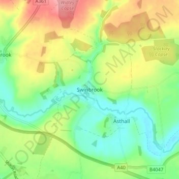
Name: Swinbrook topographic map, elevation, terrain.

Location: Swinbrook, West Oxfordshire, Oxfordshire, England, OX18 4EA, United Kingdom (51.78685 -1.61422 51.82685 -1.57422)

Average elevation: 427 ft

Minimum elevation: 292 ft

Maximum elevation: 617 ft

Other topographic maps

Click on a map to view its topography, its elevation and its terrain.

Lew

United Kingdom > England > Oxfordshire > West Oxfordshire

Average elevation: 259 ft

Churchill

United Kingdom > England > Oxfordshire > West Oxfordshire

Average elevation: 495 ft

Hailey

United Kingdom > England > Oxfordshire > West Oxfordshire

Average elevation: 371 ft

Salford

United Kingdom > England > Oxfordshire > West Oxfordshire

Average elevation: 561 ft

Ramsden

United Kingdom > England > Oxfordshire > West Oxfordshire

Average elevation: 446 ft

Lyneham

United Kingdom > England > Oxfordshire > West Oxfordshire > Lyneham

Average elevation: 430 ft

Leafield

United Kingdom > England > Oxfordshire > West Oxfordshire

Average elevation: 499 ft

Crawley

United Kingdom > England > Oxfordshire > West Oxfordshire

Average elevation: 390 ft

Fifield

United Kingdom > England > Oxfordshire > West Oxfordshire

Average elevation: 495 ft

Broadwell

United Kingdom > England > Oxfordshire > West Oxfordshire

Average elevation: 308 ft

Fifield

United Kingdom > England > Oxfordshire > West Oxfordshire

Average elevation: 495 ft

Carterton

United Kingdom > England > Oxfordshire > West Oxfordshire

Average elevation: 308 ft

Great Tew

United Kingdom > England > Oxfordshire > West Oxfordshire

Average elevation: 515 ft

Eynsham

United Kingdom > England > Oxfordshire > West Oxfordshire

Average elevation: 246 ft

Finstock

United Kingdom > England > Oxfordshire > West Oxfordshire

Average elevation: 417 ft

Burford

United Kingdom > England > Oxfordshire > West Oxfordshire

Average elevation: 423 ft

Glympton

United Kingdom > England > Oxfordshire > West Oxfordshire

Average elevation: 404 ft

Idbury

United Kingdom > England > Oxfordshire > West Oxfordshire

Average elevation: 482 ft

Wootton

United Kingdom > England > Oxfordshire > West Oxfordshire > Wootton

Average elevation: 367 ft

Spelsbury

United Kingdom > England > Oxfordshire > West Oxfordshire

Average elevation: 492 ft

Witney

United Kingdom > England > Oxfordshire > West Oxfordshire

Average elevation: 302 ft

Fawler

United Kingdom > England > Oxfordshire > West Oxfordshire

Average elevation: 384 ft

Chilson

United Kingdom > England > Oxfordshire > West Oxfordshire

Average elevation: 433 ft

Rollright

United Kingdom > England > Oxfordshire > West Oxfordshire

Average elevation: 610 ft

Ramsden

United Kingdom > England > Oxfordshire > West Oxfordshire

Average elevation: 446 ft

Kelmscott

United Kingdom > England > Oxfordshire > West Oxfordshire

Average elevation: 240 ft

Kelmscott

United Kingdom > England > Oxfordshire > West Oxfordshire

Average elevation: 240 ft

Enstone

United Kingdom > England > Oxfordshire > West Oxfordshire

Average elevation: 525 ft

Lyneham

United Kingdom > England > Oxfordshire > West Oxfordshire

Average elevation: 427 ft

Shilton

United Kingdom > England > Oxfordshire > West Oxfordshire

Average elevation: 374 ft

Fulbrook

United Kingdom > England > Oxfordshire > West Oxfordshire

Average elevation: 479 ft

Cornwell

United Kingdom > England > Oxfordshire > West Oxfordshire

Average elevation: 587 ft

Charlbury

United Kingdom > England > Oxfordshire > West Oxfordshire

Average elevation: 433 ft

Clanfield

United Kingdom > England > Oxfordshire > West Oxfordshire

Average elevation: 233 ft

Taynton

United Kingdom > England > Oxfordshire > West Oxfordshire

Average elevation: 499 ft

Swerford

United Kingdom > England > Oxfordshire > West Oxfordshire

Average elevation: 538 ft

Burford

United Kingdom > England > Oxfordshire > West Oxfordshire

Average elevation: 423 ft

Ramsden

United Kingdom > England > Oxfordshire > West Oxfordshire

Average elevation: 446 ft

Curbridge

United Kingdom > England > Oxfordshire > West Oxfordshire

Average elevation: 308 ft

Woodstock

United Kingdom > England > Oxfordshire > West Oxfordshire

Average elevation: 315 ft

Standlake

United Kingdom > England > Oxfordshire > West Oxfordshire

Average elevation: 220 ft

Eynsham

United Kingdom > England > Oxfordshire > West Oxfordshire

Average elevation: 246 ft

Kingham

United Kingdom > England > Oxfordshire > West Oxfordshire

Average elevation: 427 ft

Bampton

United Kingdom > England > Oxfordshire > West Oxfordshire

Average elevation: 236 ft

Tackley

United Kingdom > England > Oxfordshire > West Oxfordshire

Average elevation: 308 ft

Combe

United Kingdom > England > Oxfordshire > West Oxfordshire

Average elevation: 348 ft

Langford

United Kingdom > England > Oxfordshire > West Oxfordshire

Average elevation: 262 ft

Bladon

United Kingdom > England > Oxfordshire > West Oxfordshire

Average elevation: 279 ft

Westwell

United Kingdom > England > Oxfordshire > West Oxfordshire

Average elevation: 453 ft

Carterton

United Kingdom > England > Oxfordshire > West Oxfordshire

Average elevation: 312 ft

Woodstock

United Kingdom > England > Oxfordshire > West Oxfordshire

Average elevation: 315 ft

Gear up for your next adventure:

🧭Hiking Compass - Precision compass for reliable navigation in the wilderness
🦶Carbon Trekking Poles - Reduce knee impact on steep descents with ultra-light poles
🥤Water Filter Bottle - All‑in‑one filter bottle for safe hydration
🗺️NatGeo Topo Maps - High-quality waterproof printed topographic maps of US Parks
😴Insulated Sleeping Pads - Compact and warm pads for high-elevation camping

As an Amazon Associate, this site earns from qualifying purchases at no extra cost to you.