Geolocate

Baraboo topographic map

Interactive map

Click on the map to display elevation.

About this map

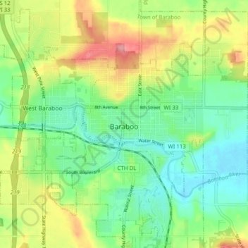
Name: Baraboo topographic map, elevation, terrain.

Location: Baraboo, Sauk County, Wisconsin, 53913, United States (43.44541 -89.78244 43.49643 -89.70506)

Average elevation: 935 ft

Minimum elevation: 807 ft

Maximum elevation: 1,145 ft

Routes: Sauk County GPS tracks, routes, trails, hikes

Other topographic maps

Click on a map to view its topography, its elevation and its terrain.

Town of Greenfield

United States > Wisconsin > Sauk County

Average elevation: 1,102 ft

Reedsburg

United States > Wisconsin > Sauk County

Average elevation: 922 ft

Spirit Lake

United States > Wisconsin > Sauk County

Devils Lake State Park offers 29 miles of hiking trails that vary based on difficulty level, length, and terrain. Among the 17 established trails, the most popular is the tumbled rocks trail. It sits at the edge of the lake on the west end, stretching a mile long. The trail is paved, allowing it to be…

Average elevation: 1,145 ft

Moon Valley

United States > Wisconsin > Sauk County

Average elevation: 817 ft

Lake Delton

United States > Wisconsin > Sauk County

Average elevation: 919 ft

Town of La Valle

United States > Wisconsin > Sauk County

Average elevation: 997 ft

Sauk City

United States > Wisconsin > Sauk County

Average elevation: 774 ft

Town of Merrimac

United States > Wisconsin > Sauk County

Average elevation: 932 ft

Merrimac

United States > Wisconsin > Sauk County

Average elevation: 820 ft

Spring Green

United States > Wisconsin > Sauk County > Spring Green

Average elevation: 725 ft

Plain

United States > Wisconsin > Sauk County

Average elevation: 863 ft