Geolocate

Hill Point topographic map

Click on the map to display elevation.

About this map

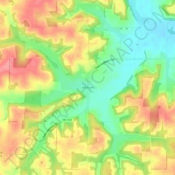
Name: Hill Point topographic map, elevation, terrain.

Location: Hill Point, Town of Washington, Sauk County, Wisconsin, United States (43.40443 -90.13263 43.44443 -90.09263)

Average elevation: 1,086 ft

Minimum elevation: 932 ft

Maximum elevation: 1,240 ft

Sauk County trails, hiking, mountain biking, running and outdoor activities

Other topographic maps

Click on a map to view its topography, its elevation and its terrain.

Spring Green

United States > Wisconsin > Sauk County

Average elevation: 725 ft

Baraboo

United States > Wisconsin > Sauk County

Average elevation: 935 ft

Town of Baraboo

United States > Wisconsin > Sauk County

Average elevation: 1,017 ft

Sauk City

United States > Wisconsin > Sauk County

Average elevation: 774 ft

Lake Delton

United States > Wisconsin > Sauk County

Average elevation: 919 ft

Reedsburg

United States > Wisconsin > Sauk County

Average elevation: 922 ft

Town of Sumpter

United States > Wisconsin > Sauk County

Average elevation: 1,024 ft

Baraboo

United States > Wisconsin > Sauk County

Average elevation: 935 ft

Plain

United States > Wisconsin > Sauk County

Average elevation: 863 ft

Gear up for your next adventure:

👓Polarized Sunglasses - Outdoor sunglasses for glare reduction
🧭Map Reading Tools - Tools and kits for map navigation
🪑Portable Camp Table - Compact table for campsite meals
🛠️Outdoor Gear Repair Kit - Essential tools to fix gear on the trail
📻Weather Alert Radios - Stay informed of storm risks while off-the-grid

As an Amazon Associate, this site earns from qualifying purchases at no extra cost to you.